| Previous Part | Main Index | Next Part |
NINEVEH AND THE FIRST COSSÆAN KINGS-THE PEOPLES OF SYRIA, THEIR TOWNS, THEIR CIVILIZATION, THEIR RELIGION-PHOENICIA.
The dynasty of Uruazagga-The Cossseans: their country, their gods, their conquest of Chaldæa-The first sovereigns of Assyria, and the first Cossæan Icings: Agumhakrimê.
The Egyptian names for Syria: Kharâ, Zahi, Lotanû, Kefâtiu-The military highway from the Nile to the Euphrates: first section from Zalu to Gaza-The Canaanites: their fortresses, their agricultural character: the forest between Jaffa and Mount Carmel, Megiddo-The three routes beyond Megiddo: Qodshu-Alasia, Naharaim, Garchemish; Mitanni and the countries beyond the Euphrates.
Disintegration of the Syrian, Canaanite, Amorite, and Khdti populations; obliteration of types-Influence of Babylon on costumes, customs, and religion—Baalim and Astarte, plant-gods and stone-gods-Religion, human sacrifices, festivals; sacred stones—Tombs and the fate of man after death-Phoenician cosmogony.
Phoenicia—Arad, Marathus, Simyra, Botrys—Byblos, its temple, its goddess, the myth of Adonis: Aphaka and the valley of the Nahr-Ibrahim, the festivals of the death and resurrection of Adonis—Berytus and its god El; Sidon and its suburbs—Tyre: its foundation, its gods, its necropolis, its domain in the Lebanon.
Isolation of the Phoenicians with regard to the other nations of Syria; their love of the sea and the causes which developed it—Legendary accounts of the beginning of their colonization—Their commercial proceedings, their banks and factories; their ships—Cyprus, its wealth, its occupations—The Phoenician colonies in Asia Minor and the Ægean Sea: purple dye—The nations of the Ægean.
177.jpg the Fortress and Bridge of Zalu
184.jpg the Canaanite Fortresses
185.jpg the Walled City of DapÛr, in Galilee
187.jpg the Migdol of Ramses Iii. At Thebes, in The Temple of Medinet-abul
189.jpg the Modern Village of BeÎtÎn (ancient Bethel), Seen from the South-west.
196.jpg the Evergreen Oaks Between Joppa and Carmel
197.jpg Acre and the Fringe of Reefs Sheltering The Ancient Port
202.jpg the Tyrian Ladder at Ras El-abiad
206.jpg the Dyke at Baiik El-kades in Its Present Condition
212.jpg the Tell of Jerabis in Its Present Condition
215.jpg the Heads of Three Amorite Captives
216.jpg Mixture of Syrian Races
218.jpg a Caricature of the Syrian Type
220.jpg Syrians Dressed in the Loin-cloth and Double Shawl
226.jpg LotanÛ Women and Children from the Tomb Of RakhmieÎ
238.jpg a Cromlech in the Neighbourhood of Hesban, In The Country of Moab
240.jpg a Corner of the Phoenician Neckropolis at Adlun
241.jpg Valley of the Tomb Of The Kings
256a.jpg the Amphitheatre of Aphaka and The Source Of The Nahh-ibrahim
269.jpg Tyre and Its Suburbs on the Mainland
273.jpg the Sculptured Rocks of Hanaweh
282.jpg One of the KafÎti from The Tomb Of RakhmirÎ
288.jpg an Egyptian Trading Vessel of the First Half Of The Xviiith Dynasty
299.jpg One of the Daggers Discovered at MycenÆ, Showing An Imitation of Egyptian Decoration
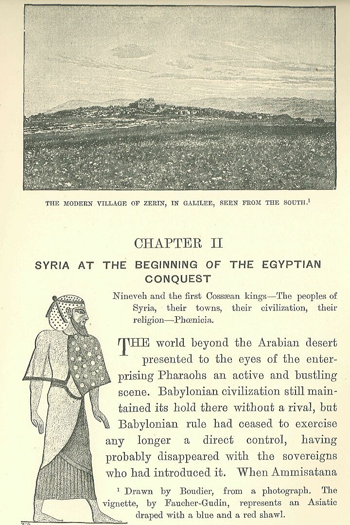
Nineveh and the first Cossæan kings—The peoples of Syria, their towns, their civilization, their religion—Phoenicia.
The world beyond the Arabian desert presented to the eyes of the enterprising Pharaohs an active and bustling scene. Babylonian civilization still maintained its hold there without a rival, but Babylonian rule had ceased to exercise any longer a direct control, having probably disappeared with the sovereigns who had introduced it. When Ammisatana died, about the year 2099, the line of Khammurabi became extinct, and a family from the Sea-lands came into power.*
     * The origin of this second dynasty and the reading of its
     name still afford matter for discussion. Amid the many
     conflicting opinions, it behoves us to remember that
     Gulkishar, the only prince of this dynasty whose title we
     possess, calls himself King of the Country of the Sea,
     that is to say, of the marshy country at the mouth of the
     Euphrates: this simple fact directs us to seek the cradle of
     the family in those districts of Southern Chaldæa. Sayce
     rejects this identification on philological and
     chronological grounds, and sees in Gulkishar, "King of the
     Sea-lands," a vassal Kaldâ prince.
This unexpected revolution of affairs did not by any means restore to the cities of Lower Chaldæa the supreme authority which they once possessed. Babylon had made such good use of its centuries of rule that it had gained upon its rivals, and was not likely now to fall back into a secondary place. Henceforward, no matter what dynasty came into power, as soon as the fortune of war had placed it upon the throne, Babylon succeeded in adopting it, and at once made it its own. The new lord of the country, Ilumaîlu, having abandoned his patrimonial inheritance, came to reside near to Merodach.*
     * The name has been read An-ma-an or Anman by Pinches,
     subsequently Ilumaîlu, Mailu, finally Anumaîlu and perhaps
     Humaîlu. The true reading of it is still unknown. Hommel
     believed he had discovered in Hilprecht's book an
     inscription belonging to the reign of this prince; but
     Hilprecht has shown that it belonged to a king of Erech,
     An-a-an, anterior to the time of An-ma-an.
He was followed during the four next centuries by a dynasty of ten princes, in uninterrupted succession. Their rule was introduced and maintained without serious opposition. The small principalities of the south were theirs by right, and the only town which might have caused them any trouble—Assur—was dependent on them, being satisfied with the title of vicegerents for its princes,—Khallu, Irishum, Ismidagan and his son Sarnsiramman I., Igurkapkapu and his son Sarnsiramman II.* As to the course of events beyond the Khabur, and any efforts Ilumaîlu's descendants may have made to establish their authority in the direction of the Mediterranean, we have no inscriptions to inform us, and must be content to remain in ignorance. The last two of these princes, Melamkurkurra and Eâgamîl, were not connected with each other, and had no direct relationship with their predecessors.** The shortness of their reigns presents a striking contrast with the length of those preceding them, and probably indicates a period of war or revolution. When these princes disappeared, we know not how or why, about the year 1714 B.C., they were succeeded by a king of foreign extraction; and one of the semi-barbarous race of Kashshu ascended the throne which had been occupied since the days of Khammurabi by Chaldæans of ancient stock.***
     * Inscription of Irishum, son of Khallu, on a brick found at
     Kalah-Shergat, and an inscription of Sarnsiramman II., son
     of Igurkapkapu, on another brick from the same place.
     Sarnsiramman I. and his father Ismidagan are mentioned in
     the great inscription of Tiglath-pileser II., as having
     lived 641 years before King Assurdân, who himself had
     preceded Tiglath-pileser by sixty years: they thus reigned
     between 1900 and 1800 years before our era, according to
     tradition, whose authenticity we have no other means of
     verifying.

     ** The name of the last is read Eâgamîl, for want of
     anything better: Oppert makes it Eâgâ, simply transcribing
     the signs; and Hilprecht, who took up the question again
     after him, has no reading to propose.

     *** I give here the list of the kings of the second dynasty,
     from the documents discovered by Pinches: No monument
     remains of any of these princes, and even the reading of
     their names is merely provisional: those placed between
     brackets represent Delitzsch's readings. A Gulkishar is
     mentioned in an inscription of Belnadiuabal; but Jensen is
     doubtful if the Gulkishar mentioned in this place is
     identical with the one in the lists.
These Kashshu, who spring up suddenly out of obscurity, had from the earliest times inhabited the mountainous districts of Zagros, on the confines of Elymai's and Media, where the Cossæans of the classical historians flourished in the time of Alexander.*
* The Kashshu are identified with the Cossæans by Sayce, by Schrader, by Fr. Delitzsch, by Halévy, by Tiele, by Hommel, and by Jensen. Oppert maintains that they answer to the Kissians of Herodotus, that is to say, to the inhabitants of the district of which Susa is the capital. Lehmann supports this opinion. Winckler gives none, and several Assyriologists incline to that of Kiepert, according to which the Kissians are identical with the Cossæans.
It was a rugged and unattractive country, protected by nature and easy to defend, made up as it was of narrow tortuous valleys, of plains of moderate extent but of rare fertility, of mountain chains whose grim sides were covered with forests, and whose peaks were snow-crowned during half the year, and of rivers, or, more correctly speaking, torrents, for the rains and the melting of the snow rendered them impassable in spring and autumn. The entrance to this region was by two or three well-fortified passes: if an enemy were unwilling to incur the loss of time and men needed to carry these by main force, he had to make a detour by narrow goat-tracks, along which the assailants were obliged to advance in single file, as best they could, exposed to the assaults of a foe concealed among the rocks and trees. The tribes who were entrenched behind this natural rampart made frequent and unexpected raids upon the marshy meadows and fat pastures of Chaldæa: they dashed through the country, pillaging and burning all that came in their way, and then, quickly regaining their hiding-places, were able to place their booty in safety before the frontier garrisons had recovered from the first alarm.* These tribes were governed by numerous chiefs acknowledging a single king—ianzi—whose will was supreme over nearly the whole country:** some of them had a slight veneer of Chaldæan civilization, while among the rest almost every stage of barbarism might be found. The remains of their language show that it was remotely allied to the dialect of Susa, and contained many Semitic words.*** What is recorded of their religion reaches us merely at second hand, and the groundwork of it has doubtless been modified by the Babylonian scribes who have transmitted it to us.****
     * It was thus in the time of Alexander and his successors,
     and the information given by the classical historians about
     this period is equally applicable to earlier times, as we
     may conclude from the numerous passages from Assyrian
     inscriptions which have been collected by Fr. Delitzsch.

     ** Delitzsch conjectures that Ianzi, or Ianzu, had
     become a kind of proper name, analogous to the term
     Pharaoh employed by the Egyptians.

     *** A certain number of Cossæan words has been preserved and
     translated, some in one of the royal Babylonian lists, and
     some on a tablet in the British Museum, discovered and
     interpreted by Fr. Delitzsch. Several Assyriologists think
     that they showed a marked affinity with the idiom of the
     Susa inscriptions, and with that of the Achæmenian
     inscriptions of the second type; others deny the proposed
     connection, or suggest that the Cossæan language was a
     Semitic dialect, related to the Chaldæo-Assyrian. Oppert,
     who was the first to point out the existence of this
     dialect, thirty years ago, believed it to be the Elamite; he
     still persists in his opinion, and has published several
     notes in defence of it.

     **** It has been studied by Pr. Delitzsch, who insists on
     the influence which daily intercourse with the Chaldæans had
     on it after the conquest; Halévy, in most of the names of
     the gods given as Cossæan, sees merely the names of Chaldæan
     divinities slightly disguised in the writing.
They worshipped twelve great gods, of whom the chief—Kashshu, the lord of heaven-gave his name to the principal tribe, and possibly to the whole race:* Shûmalia, queen of the snowy heights, was enthroned beside him,** and the divinities next in order were, as in the cities of the Euphrates, the Moon, the Sun (Sakh or Shuriash), the air or the tempest (Ubriash), and Khudkha.*** Then followed the stellar deities or secondary incarnations of the sun,—Mirizir, who represented both Istar and Beltis; and Khala, answering to Gula.****
     * The existence of Kashshu is proved by the name of
     Kashshunadinakhé: Ashshur also bore a name identical with
     that of his worshippers.

     ** She is mentioned in a rescript of Nebuchadrezzar I., at
     the head of the gods of Namar, that is to say, the Cossæan
     deities, as "the lady of the shining mountains, the
     inhabitants of the summits, the frequenter of peaks." She is
     called Shimalia in Rawlinson, but Delitzsch has restored her
     name which was slightly mutilated; one of her statues was
     taken by Samsirammân III., King of Assyria, in one of that
     sovereign's campaigns against Chaldæa.

     *** All these identifications are furnished by the glossary
     of Delitzsch. Ubriash, under the form of Buriash, is met
     with in a large number of proper names, Burnaburiash,
     Shagashaltiburiash, Ulamburiash, Kadashmanburiash, where the
     Assyrian scribe translates it Bel-matâti, lord of the
     world: Buriash is, therefore, an epithet of the god who was
     called Rammân in Chaldæa. The name of the moon-god is
     mutilated, and only the initial syllable Shi... remains,
     followed by an indistinct sign: it has not yet been
     restored.

     **** Halévy considers Khala, or Khali, as a harsh form of
     Gula: if this is the case, the Cossæans must have borrowed
     the name, and perhaps the goddess herself, from their
     Chaldæan neighbours.
The Chaldæan Ninip corresponded both to Gidar and Maruttash, Bel to Kharbe and Turgu, Merodach to Shipak, Nergal to Shugab.* The Cossæan kings, already enriched by the spoils of their neighbours, and supported by a warlike youth, eager to enlist under their banner at the first call,** must have been often tempted to quit their barren domains and to swoop down on the rich country which lay at their feet. We are ignorant of the course of events which, towards the close of the XVIIIth century B.C., led to their gaining possession of it. The Cossæan king who seized on Babylon was named Gandish, and the few inscriptions we possess of his reign are cut with a clumsiness that betrays the barbarism of the conqueror. They cover the pivot stones on which Sargon of Agadê or one of the Bursins had hung the doors of the temple of Nippur, but which Gandish dedicated afresh in order to win for himself, in the eyes of posterity, the credit of the work of these sovereigns.***
     * Hilprecht has established the identity of Turgu with Bel
     of Nippur.

     ** Strabo relates, from some forgotten historian of
     Alexander, that the Cossæans "had formerly been able to
     place as many as thirteen thousand archers in line, in the
     wars which they waged with the help of the Elymæans against
     the inhabitants of Susa and Babylon."

     *** The full name of this king, Gandish or Gandash, which is
     furnished by the royal lists, is written Gaddash on a
     monument in the British Museum discovered by Pinches, whose
     conclusions have been erroneously denied by Winckler. A
     process of abbreviation, of which there are examples in the
     names of other kings of the same dynasty, reduced the name
     to Gandê in the current language.
Bel found favour in the eyes of the Cossæans who saw in him Kharbê or Turgu, the recognised patron of their royal family: for this reason Gandish and his successors regarded Bel with peculiar devotion. These kings did all they could for the decoration and endowment of the ancient temple of Ekur, which had been somewhat neglected by the sovereigns of purely Babylonian extraction, and this devotion to one of the most venerated Chaldæan sanctuaries contributed largely towards their winning the hearts of the conquered people.*
     * Hilpreoht calls attention on this point to the fact that
     no one has yet discovered at Nippur a single ex-voto
     consecrated by any king of the two first Babylonian
     dynasties.
The Cossæan rule over the countries of the Euphrates was doubtless similar in its beginnings to that which the Hyksôs exercised at first over the nomes of Egypt. The Cossæan kings did not merely bring with them an army to protect their persons, or to occupy a small number of important posts; they were followed by the whole nation, and spread themselves over the entire country. The bulk of the invaders instinctively betook themselves to districts where, if they could not resume the kind of life to which they were accustomed in their own land, they could, at least give full rein to their love of a free and wild existence. As there were no mountains in the country, they turned to the marshes, and, like the Hyksôs in Egypt, made themselves at home about the mouths of the rivers, on the half-submerged low lands, and on the sandy islets of the lagoons which formed an undefined borderland between the alluvial region and the Persian Gulf. The covert afforded, by the thickets furnished scope for the chase which these hunters had been accustomed to pursue in the depths of their native forests, while fishing, on the other hand, supplied them with an additional element of food. When their depredations drew down upon them reprisals from their neighbours, the mounds occupied, by their fortresses, and surrounded by muddy swamps, offered them almost as secure retreats as their former strongholds on the lofty sides of the Zagros. They made alliances with the native Aramæans—with those Kashdi, properly called Chaldæans, whose name we have imposed upon all the nations who, from a very early date, bore rule on the banks of the Lower Euphrates. Here they formed themselves into a State—Karduniash—whose princes at times rebelled, against all external authority, and at other times acknowledged the sovereignty of the Babylonian monarchs.*
     * The state of Karduniash, whose name appears for the first
     time on the monuments of the Cossæan period, has been
     localised in a somewhat vague manner, in the south of
     Babylonia, in the country of the Kashdi, and afterwards
     formally identified with the Countries of the Sea, and
     with the principality which was called Bît-Yâkin in the
     Assyrian period. In the Tel-el-Amarna tablets the name is
     already applied to the entire country occupied by the
     Cossæan kings or their descendants, that is to say, to the
     whole of Babylonia. Sargon II. at that time distinguishes
     between an Upper and a Lower Karduniash; and in consequence
     the earliest Assyriologists considered it as an Assyrian
     designation of Babylon, or of the district surrounding it,
     an opinion which was opposed by Delitzsch, as he believed it
     to be an indigenous term which at first indicated the
     district round Babylon, and afterwards the whole of
     Babylonia. From one frequent spelling of the name, the
     meaning appears to have been Fortress of Duniash; to this
     Delitzsch preferred the translation Garden of Duniash,
     from an erroneous different reading—Ganduniash: Duniash, at
     first derived from a Chaldæan God Dun, whose name may
     exist in Dunghi, is a Cossæan name, which the Assyrians
     translated, as they did Buriash, Belmatâti, lord of the
     country. Winckler rejects the ancient etymology, and
     proposes to divide the word as Kardu-niash and to see in it
     a Cossæan translation of the expression mât-kaldi, country
     of the Caldæans: Hommel on his side, as well as Delitzsch,
     had thought of seeking in the Chaldæans proper—Kaldi for
     Kashdi, or Kash-da, "domain of the Cossæans "—the
     descendants of the Cossæans of Karduniash, at least as far
     as race is concerned. In the cuneiform texts the name is
     written Kara—D. P. Duniyas, "the Wall of the god
     Duniyas" (cf. the Median Wall or Wall of Semiramis which
     defended Babylonia on the north).
The people of Sumir and Akkad, already a composite of many different races, absorbed thus another foreign element, which, while modifying its homogeneity, did not destroy its natural character. Those Cossæan tribes who had not quitted their own country retained their original barbarism, but the hope of plunder constantly drew them from their haunts, and they attacked and devastated the cities of the plain unhindered by the thought that they were now inhabited by their fellow-countrymen. The raid once over, many of them did not return home, but took service under some distant foreign ruler—the Syrian princes attracting many, who subsequently became the backbone of their armies,* while others remained at Babylon and enrolled themselves in the body-guard of the kings.
     * Halévy has at least proved that the Khabiri mentioned in.
     the Tel el-Amarna tablets were Cossæans, contrary to the
     opinion of Sayce, who makes them tribes grouped round
     Hebron, which W. Max Müller seems to accept; Winckler,
     returning to an old opinion, believes them to have been
     Hebrews.
To the last they were an undisciplined militia, dangerous, and difficult to please: one day they would hail their chiefs with acclamations, to kill them the next in one of those sudden outbreaks in which they were accustomed to make and unmake their kings.* The first invaders were not long in acquiring, by means of daily intercourse with the old inhabitants, the new civilization: sooner or later they became blended with the natives, losing all their own peculiarities, with the exception of their outlandish names, a few heroic legends,** and the worship of two or three gods—Shûmalia, Shugab, and Shukamuna.
     * This is the opinion of Hommel, supported by the testimony
     of the Synchronous Hist.: in this latter document the
     Cossæans are found revolting against King Kadashmankharbé,
     and replacing him on the throne by a certain Nazibugash, who
     was of obscure origin.

     ** Pr. Delitzsch and Schrader compare their name with that
     of Kush, who appears in the Bible as the father of Nimrod
     (Gen. x. 8-12); Hommel and Sayce think that the history of
     Nimrod is a reminiscence of the Cossæan rule. Jensen is
     alone in his attempt to attribute to the Cossæans the first
     idea of the epic of Gilgames.
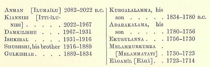
As in the case of the Hyksôs in Africa, the barbarian conquerors thus became merged in the more civilized people which they had subdued. This work of assimilation seems at first to have occupied the whole attention of both races, for the immediate successors of Gandish were unable to retain under their rule all the provinces of which the empire was formerly composed. They continued to possess the territory situated on the middle course of the Euphrates as far as the mouth of the Balikh, but they lost the region extending to the east of the Khabur, at the foot of the Masios, and in the upper basin of the Tigris: the vicegerents of Assur also withdrew from them, and, declaring that they owed no obedience excepting to the god of their city, assumed the royal dignity. The first four of these kings whose names have come down to us, Sulili, Belkapkapu, Adasi, and Belbâni,* appear to have been but indifferent rulers, but they knew bow to hold their own against the attacks of their neighbours, and when, after a century of weakness and inactivity, Babylon reasserted herself, and endeavoured to recover her lost territory, they had so completely established their independence that every attack on it was unsuccessful. The Cossæan king at that time—an active and enterprising prince, whose name was held in honour up to the days of the Ninevite supremacy—was Agumkakrimê, the son of Tassigurumash.**
     * These four names do not so much represent four consecutive
     reigns as two separate traditions which were current
     respecting the beginnings of Assyrian royalty. The most
     ancient of them gives the chief place to two personages
     named Belkapkapu and Sulili; this tradition has been
     transmitted to us by Rammânnirâri III., because it connected
     the origin of his race with these kings. The second
     tradition placed a certain Belbâni, the son of Adasi, in the
     room of Belkapkapu and Sulili: Esarhaddon made use of it in
     order to ascribe to his own family an antiquity at least
     equal to that of the family to which Rammânnirâri III.
     belonged. Each king appropriated from the ancient popular
     traditions those names which seemed to him best calculated
     to enhance the prestige of his dynasty, but we cannot tell
     how far the personages selected enjoyed an authentic
     historical existence: it is best to admit them at least
     provisionally into the royal series, without trusting too
     much to what is related of them.

     ** The tablet discovered by Pinches is broken after the
     fifth king of the dynasty. The inscription of Agumkakrimê,
     containing a genealogy of this prince which goes back as far
     as the fifth generation, has led to the restoration of the
     earlier part of the list as follows:

     Gandish, Gaddash, Adumitasii .... 1655-? B.C.
     Gandê ........................... 1714-1707 B.C.
     Tassigurumash.................... ?
     Agumrabi, his son................ 1707-1685
     Agumkakrimê ..................... ?
     [A]guyashi ...................... 1685-1663
     Ushshi, his son.................. 1663-1655
This "brilliant scion of Shukamuna" entitled himself lord of the Kashshu and of Akkad, of Babylon the widespread, of Padan, of Alman, and of the swarthy Guti.* Ashnunak had been devastated; he repeopled it, and the four "houses of the world" rendered him obedience; on the other hand, Elam revolted from its allegiance, Assur resisted him, and if he still exercised some semblance of authority over Northern Syria, it was owing to a traditional respect which the towns of that country voluntarily rendered to him, but which did not involve either subjection or control. The people of Khâni still retained possession of the statues of Merodach and of his consort Zarpanit, which had been stolen, we know not how, some time previously from Chaldæa.** Agumkakrimê recovered them and replaced them in their proper temple. This was an important event, and earned him the good will of the priests.
     * The translation black-headed, i.e. dark-haired and
     complexioned, Guti, is uncertain; Jensen interprets the
     epithet nishi saldati to mean "the Guti, stupid (foolish?
     culpable?) people." The Guti held both banks of the lower
     Zab, in the mountains on the east of Assyria. Delitzsch has
     placed Padan and Alman in the mountains to the east of the
     Diyâleh; Jensen places them in the chain of the Khamrîn, and
     Winckler compares Alman or Halman with the Holwân of the
     present day.

     ** The Khâni have been placed by Delitzsch in the
     neighbourhood of Mount Khâna, mentioned in the accounts of
     the Assyrian campaigns, that is to say, in the Amanos,
     between the Euphrates and the bay of Alexandretta: he is
     inclined to regard the name as a form of that of the Khâti.
The king reorganised public worship; he caused new fittings for the temples to be made to take the place of those which had disappeared, and the inscription which records this work enumerates with satisfaction the large quantities of crystal, jasper, and lapis-lazuli which he lavished on the sanctuary, the utensils of silver and gold which he dedicated, together with the "seas" of wrought bronze decorated with monsters and religious emblems.* This restoration of the statues, so flattering to the national pride and piety, would have been exacted and insisted upon by a Khammurabi at the point of the sword, but Agumkakrimê doubtless felt that he was not strong enough to run the risk of war; he therefore sent an embassy to the Khâni, and such was the prestige which the name of Babylon still possessed, from the deserts of the Caspian to the shores of the Mediterranean, that he was able to obtain a concession from that people which he would probably have been powerless to extort by force of arms.**
     * We do not possess the original of the inscription which
     tells us of these facts, but merely an early copy.

     ** Strictly speaking, one might suppose that a war took
     place; but most Assyriologists declare unhesitatingly that
     there was merely an embassy and a diplomatic negotiation.
The Egyptians had, therefore, no need to anticipate Chaldæan interference when, forsaking their ancient traditions, they penetrated for the first time into the heart of Syria. Not only was Babylon no longer supreme there, but the coalition of those cities on which she had depended for help in subduing the West was partially dissolved, and the foreign princes who had succeeded to her patrimony were so far conscious of their weakness, that they voluntarily kept aloof from the countries in which, previous to their advent, Babylon had held undivided sway. The Egyptian conquest of Syria had already begun in the days of Agumkakrimê, and it is possible that dread of the Pharaoh was one of the chief causes which influenced the Cossæans to return a favourable answer to the Khâni. Thûtmosis I., on entering Syria, encountered therefore only the native levies, and it must be admitted that, in spite of their renowned courage, they were not likely to prove formidable adversaries in Egyptian estimation. Not one of the local Syrian dynasties was sufficiently powerful to collect all the forces of the country around its chief, so as to oppose a compact body of troops to the attack of the African armies. The whole country consisted of a collection of petty states, a complex group of peoples and territories which even the Egyptians themselves never completely succeeded in disentangling. They classed the inhabitants, however, under three or four very comprehensive names—Kharû, Zahi, Lotanû, and Kefâtiû—all of which frequently recur in the inscriptions, but without having always that exactness of meaning we look for in geographical terms. As was often the case in similar circumstances, these names were used at first to denote the districts close to the Egyptian frontier with which the inhabitants of the Delta had constant intercourse. The Kefâtiû seem to have been at the outset the people of the sea-coast, more especially of the region occupied later by the Phoenicians, but all the tribes with whom the Phoenicians came in contact on the Asiatic and European border were before long included under the same name.*
     * The Kefâtiû, whose name was first read Kefa, and later
     Kefto, were originally identified with the inhabitants of
     Cyprus or Crete, and subsequently with those of Cilicia,
     although the decree of Canopus locates them in Phoenicia.
Zahi originally comprised that portion of the desert and of the maritime plain on the north-east of Egypt which was coasted by the fleets, or traversed by the armies of Egypt, as they passed to and fro between Syria and the banks of the Nile. This region had been ravaged by Ahmosis during his raid upon Sharuhana, the year after the fall of Avaris. To the south-east of Zahi lay Kharû; it included the greater part of Mount Seir, whose wadys, thinly dotted over with oases, were inhabited by tribes of more or less stationary habits. The approaches to it were protected by a few towns, or rather fortified villages, built in the neighbourhood of springs, and surrounded by cultivated fields and poverty-stricken gardens; but the bulk of the people lived in tents or in caves on the mountain-sides. The Egyptians constantly confounded those Khauri, whom the Hebrews in after-times found scattered among the children of Edom, with the other tribes of Bedouin marauders, and designated them vaguely as Shaûsû. Lotanû lay beyond, to the north of Kharû and to the north-east of Zahi, among the hills which separate the "Shephelah" from the Jordan.*
     * The name of Lotanû or Rotanû has been assigned by Brugsch
     to the Assyrians, but subsequently, by connecting it, more
     ingeniously than plausibly, with the Assyrian iltânu, he
     extended it to all the peoples of the north; we now know
     that in the texts it denotes the whole of Syria, and, more
     generally, all the peoples dwelling in the basins of the
     Orontes and the Euphrates. The attempt to connect the name
     Rotanû or Lotanû with that of the Edomite tribe of Lotan
     (Gen. xxxvi. 20, 22) was first made by P. de Saulcy; it was
     afterwards taken up by Haigh and adopted by Renan.
Drawn by Faucher-Gudin,
from a photograph by Insinger.
As it was more remote from the isthmus, and formed the Egyptian horizon in that direction, all the new countries with which the Egyptians became acquainted beyond its northern limits were by degrees included under the one name of Lotanû, and this term was extended to comprise successively the entire valley of the Jordan, then that of the Orontes, and finally even that of the Euphrates. Lotanû became thenceforth a vague and fluctuating term, which the Egyptians applied indiscriminately to widely differing Asiatic nations, and to which they added another indefinite epithet when they desired to use it in a more limited sense: that part of Syria nearest to Egypt being in this case qualified as Upper Lotanû, while the towns and kingdoms further north were described as being in Lower Lotanû. In the same way the terms Zahi and Kharû were extended to cover other and more northerly regions. Zahi was applied to the coast as far as the mouth of the Nahr el-Kebir and to the country of the Lebanon which lay between the Mediterranean and the middle course of the Orontes. Kharû ran parallel to Zahi, but comprised the mountain district, and came to include most of the countries which were at first ranged under Upper Lotanû; it was never applied to the region beyond the neighbourhood of Mount Tabor, nor to the trans-Jordanie provinces. The three names in their wider sense preserved the same relation to each other as before, Zahi lying to the west and north-west of Kharû, and Lower Lotanû to the north of Kharû and north-east of Zahi, but the extension of meaning did not abolish the old conception of their position, and hence arose confusion in the minds of those who employed them; the scribes, for instance, who registered in some far-off Theban temple the victories of the Pharaoh would sometimes write Zahi where they should have inscribed Kharû, and it is a difficult matter for us always to detect their mistakes. It would be unjust to blame them too severely for their inaccuracies, for what means had they of determining the relative positions of that confusing collection of states with which the Egyptians came in contact as soon as they had set foot on Syrian soil?
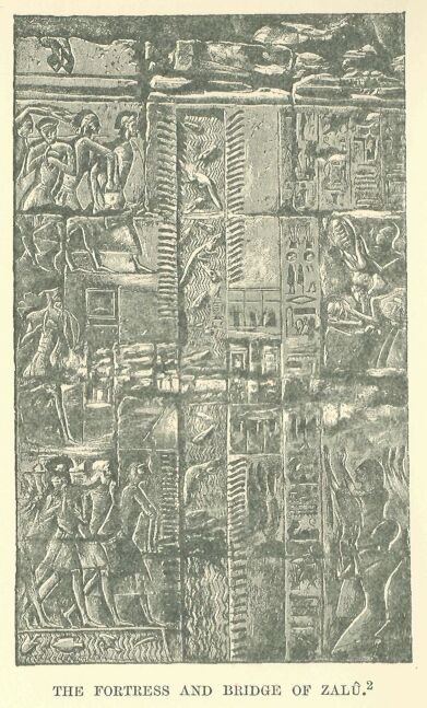
A choice of several routes into Asia, possessing unequal advantages, was open to the traveller, but the most direct of them passed through the town of Zalû. The old entrenchments running from the Ked Sea to the marshes of the Pelusiac branch still protected the isthmus, and beyond these, forming an additional defence, was a canal on the banks of which a fortress was constructed. This was occupied by the troops who guarded the frontier, and no traveller was allowed to pass without having declared his name and rank, signified the business which took him into Syria or Egypt, and shown the letters with which he was entrusted.*
     * The notes of an official living at Zalu in the time of
     Mîneptah are preserved on the back of pls. v., vi. of the
     Anastasi Papyrus III,; his business was to keep a register
     of the movements of the comers and goers between Egypt and
     Syria during a few days of the month Pakhons, in the year
     III.
It was from Zalû that the Pharaohs set out with their troops, when summoned to Kharû by a hostile confederacy; it was to Zalû they returned triumphant after the campaign, and there, at the gates of the town, they were welcomed by the magnates of the kingdom. The road ran for some distance over a region which was covered by the inundation of the Nile during six months of the year; it then turned eastward, and for some distance skirted the sea-shore, passing between the Mediterranean and the swamp which writers of the Greek period called the Lake of Sirbonis.*
     * The Sirbonian Lake is sometimes half full of water,
     sometimes almost entirely dry; at the present time it bears
     the name of Sebkhat Berdawil, from King Baldwin I. of
     Jerusalem, who on his return from his Egyptian campaign died
     on its shores, in 1148, before he could reach El-Artsh.
This stage of the journey was beset with difficulties, for the Sirbonian Lake did not always present the same aspect, and its margins were constantly shifting. When the canals which connected it with the open sea happened to become obstructed, the sheet of water subsided from evaporation, leaving in many places merely an expanse of shifting mud, often concealed under the sand which the wind brought up from the desert. Travellers ran imminent risk of sinking in this quagmire, and the Greek historians tell of large armies being almost entirely swallowed up in it. About halfway along the length of the lake rose the solitary hill of Mount Casios; beyond this the sea-coast widened till it became a vast slightly undulating plain, covered with scanty herbage, and dotted over with wells containing an abundant supply of water, which, however, was brackish and disagreeable to drink.
Beyond these lay a grove of palms, a brick prison, and a cluster of miserable houses, bounded by a broad wady, usually dry. The bed of the torrent often served as the boundary between Africa and Asia, and the town was for many years merely a convict prison, where ordinary criminals, condemned to mutilation and exile, were confined; indeed, the Greeks assure us that it owed its name of Rhinocolûra to the number of noseless convicts who were to be seen there.*
     * The ruins of the ancient town, which were of considerable
     extent, are half buried under the sand, out of which an
     Egyptian naos of the Ptolemaic period has been dug, and
     placed near the well which supplies the fort, where it
     serves as a drinking trough for the horses. Brugsch believed
     he could identify its site with that of the Syrian town
     Hurnikheri, which he erroneously reads Harinkola; the
     ancient form of the name is unknown, the Greek form varies
     between Rhinocorûra and Rhinocolûra. The story of the
     mutilated convicts is to be found in Diodorus Siculus, as
     well as in Strabo; it rests on a historical fact. Under the
     XVIIIth dynasty Zalû was used as a place of confinement for
     dishonest officials. For this purpose it was probably
     replaced by Rhinocolûra, when the Egyptian frontier was
     removed from the neighbourhood of Selle to that of El-Arîsh.
At this point the coast turns in a north-easterly direction, and is flanked with high sand-hills, behind which the caravans pursue their way, obtaining merely occasional glimpses of the sea. Here and there, under the shelter of a tower or a half-ruined fortress, the traveller would have found wells of indifferent water, till on reaching the confines of Syria he arrived at the fortified village of Raphia, standing like a sentinel to guard the approach to Egypt. Beyond Raphia vegetation becomes more abundant, groups of sycamores and mimosas and clusters of date-palms appear on the horizon, villages surrounded with fields and orchards are seen on all sides, while the bed of a river, blocked with gravel and fallen rocks, winds its way between the last fringes of the desert and the fruitful Shephelah;* on the further bank of the river lay the suburbs of Gaza, and, but a few hundred yards beyond, Gaza itself came into view among the trees standing on its wall-crowned hill.**
     * The term Shephelah signifies the plain; it is applied by
     the Biblical writers to the plain bordering the coast, from
     the heights of Gaza to those of Joppa, which were inhabited
     at a later period by the Philistines (Josh. xi. 16; Jer.
     xxxii. 44 and xxxiii. 13).

     ** Guérin describes at length the road from Gaza to Raphia.
     The only town of importance between them in the Greek period
     was Iênysos, the ruins of which are to be found near Khan
     Yunes, but the Egyptian name for this locality is unknown:
     Aunaugasa, the name of which Brugsch thought he could
     identify with it, should be placed much farther away, in
     Northern or in Coele-Syria.
The Egyptians, on their march from the Nile valley, were wont to stop at this spot to recover from their fatigues; it was their first halting-place beyond the frontier, and the news which would reach them here prepared them in some measure for what awaited them further on. The army itself, the "troop of Râ," was drawn from four great races, the most distinguished of which came, of course, from the banks of the Nile: the Amû, born of Sokhît, the lioness-headed goddess, were classed in the second rank; the Nahsi, or negroes of Ethiopia, were placed in the third; while the Timihû, or Libyans, with the white tribes of the north, brought up the rear. The Syrians belonged to the second of these families, that next in order to the Egyptians, and the name of Amu, which for centuries had been given them, met so satisfactorily all political, literary, or commercial requirements, that the administrators of the Pharaohs never troubled themselves to discover the various elements concealed beneath the term. We are, however, able at the present time to distinguish among them several groups of peoples and languages, all belonging to the same family, but possessing distinctive characteristics. The kinsfolk of the Hebrews, the children of Ishmael and Edom, the Moabites and Ammonites, who were all qualified as Shaûsû, had spread over the region to the south and east of the Dead Sea, partly in the desert, and partly on the confines of the cultivated land. The Canaanites were not only in possession of the coast from Gaza to a point beyond the Nahr el-Kebir, but they also occupied almost the whole valley of the Jordan, besides that of the Litâny, and perhaps that of the Upper Orontes.* There were Aramaean settlements at Damascus, in the plains of the Lower Orontes, and in Naharaim.**
     * I use the term Canaanite with the meaning most frequently
     attached to it, according to the Hebrew use (Gen. x. 15-
     19). This word is found several times in the Egyptian texts
     under the forms Kinakhna, Kinakhkhi, and probably Kûnakhaîû,
     in the cuneiform texts of Tel el-Amarna.

     ** As far as I know, the term Aramæan is not to be found in
     any Egyptian text of the time of the Pharaohs: the only
     known example of it is a writer's error corrected by Chabas.
     W. Max Müller very justly observes that the mistake is
     itself a proof of the existence of the name and of the
     acquaintance of the Egyptians with it.
The country beyond the Aramaean territory, including the slopes of the Amanos and the deep valleys of the Taurus, was inhabited by peoples of various origin; the most powerful of these, the Khâti, were at this time slowly forsaking the mountain region, and spreading by degrees over the country between the Afrîn and the Euphrates.*
The Canaanites were the most numerous of all these groups, and had they been able to amalgamate under a single king, or even to organize a lasting confederacy, it would have been impossible for the Egyptian armies to have broken through the barrier thus raised between them and the rest of Asia; but, unfortunately, so far from showing the slightest tendency towards unity or concentration, the Canaanites were more hopelessly divided than any of the surrounding nations. Their mountains contained nearly as many states as there were valleys, while in the plains each town represented a separate government, and was built on a spot carefully selected for purposes of defence. The land, indeed, was chequered with these petty states, and so closely were they crowded together, that a horseman, travelling at leisure, could easily pass through two or three of them in a day's journey.**
     * Thûtmosis III. shows that, at any rate, they were
     established in these regions about the XVIth century B.C.
     The Egyptian pronunciation of their name is Khîti, with
     the feminine Khîtaît, Khîtit; but the Tel el-Amarna texts
     employ the vocalisation Khâti, Khâte, which must be more
     correct than that of the Egyptians, The form Khîti seems
     to me to be explicable by an error of popular etymology.
     Egyptian ethnical appellations in îti formed their plural
     by -âtiû, -âteê, -âti, -âte, so that if Khâte, Khâti,
     were taken for a plural, it would naturally have suggested
     to the scribes the form Khîti for the singular.

     ** Thûtmosis III., speaking to his soldiers, tells them that
     all the chiefs the projecting spur of some mountain, or on a
     solitary and more or less irregularly shaped eminence in the
     midst of a plain, and the means of defence in the country
     are shut up in Megiddo, so that "to take it is to take a
     thousand cities:" this is evidently a hyperbole in the mouth
     of the conqueror, but the exaggeration itself shows how
     numerous were the chiefs and consequently the small states
     in Central and Southern Syria.
Not only were the royal cities fenced with walls, but many of the surrounding villages were fortified, while the watch-towers, or migdols* built at the bends of the roads, at the fords over the rivers, and at the openings of the ravines, all testified to the insecurity of the times and the aptitude for self-defence shown by the inhabitants.
     * This Canaanite word was borrowed by the Egyptians from the
     Syrians at the beginning of their Asiatic wars; they
     employed it in forming the names of the military posts which
     they established on the eastern frontier of the Delta: it
     appears for the first time among Syrian places in the list
     of cities conquered by Thûtmosis III.
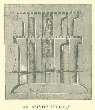
Drawn by Faucher-Gudin,
from a photograph by Beato.
The aspect of these migdols, or forts, must have appeared strange to the first Egyptians who beheld them. These strongholds bore no resemblance to the large square or oblong enclosures to which they were accustomed, and which in their eyes represented the highest skill of the engineer. In Syria, however, the positions suitable for the construction of fortresses hardly ever lent themselves to a symmetrical plan. The usual sites had to be adapted in each case to suit the particular configuration of the ground.
     Drawn by Faucher-Gudin, from a photograph taken at Karnak by
     Beato.
It was usually a mere wall of stone or dried brick, with towers at intervals; the wall measuring from nine to twelve feet thick at the base, and from thirty to thirty-six feet high, thus rendering an assault by means of portable ladders, nearly impracticable.*
     * This is, at least, the result of investigations made by
     modern engineers who have studied these questions of
     military archæology.
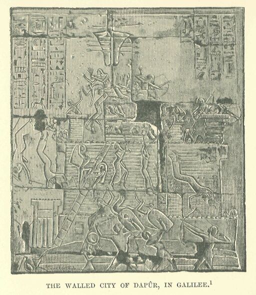
The gateway had the appearance of a fortress in itself. It was composed of three large blocks of masonry, forming a re-entering face, considerably higher than the adjacent curtains, and pierced near the top with square openings furnished with mantlets, so as to give both a front and flank view of the assailants. The wooden doors in the receded face were covered with metal and raw hides, thus affording a protection against axe or fire.*
     * Most of the Canaanite towns, taken by Ramses II. in the
     campaign of his VIIIth year were fortified in this manner.
     It must have been the usual method of fortification, as it
     seems to have served as a type for conventional
     representation, and was sometimes used to denote cities
     which had fortifications of another kind. For instance,
     Dapûr-Tabor is represented in this way, while a picture on
     another monument, which is reproduced in the illustration on
     page 185, represents what seems to have been the particular
     form of its encompassing walls.
The building was strong enough not only to defy the bands of adventurers who roamed the country, but was able to resist for an indefinite time the operations of a regular siege. Sometimes, however, the inhabitants when constructing their defences did not confine themselves to this rudimentary plan, but threw up earthworks round the selected site. On the most exposed side they raised an advance wall, not exceeding twelve or fifteen feet in height, at the left extremity of which the entrance was so placed that the assailants, in endeavouring to force their way through, were obliged to expose an unprotected flank to the defenders. By this arrangement it was necessary to break through two lines of fortification before the place could be entered. Supposing the enemy to have overcome these first obstacles, they would find themselves at their next point of attack confronted with a citadel which contained, in addition to the sanctuary of the principal god, the palace of the sovereign himself. This also had a double enclosing wall and massively built gates, which could be forced only at the expense of fresh losses, unless the cowardice or treason of the garrison made the assault an easy one.*
     * The type of town described in the text is based on a
     representation on the walls of Karnak, where the siege of
     Dapûr-Tabor by Ramses II. is depicted. Another type is given
     in the case of Ascalon.
     Drawn by Faucher-Gudin, from a photograph taken by Dévéria
     in 1865.
Of these bulwarks of Canaanite civilization, which had been thrown up by hundreds on the route of the invading hosts, not a trace is to be seen to-day. They may have been razed to the ground during one of those destructive revolutions to which the country was often exposed, or their remains may lie hidden underneath the heaps of ruins which thirty centuries of change have raised over them.*
     * The only remains of a Canaanite fortification which can be
     assigned to the Egyptian period are those which Professor
     F. I. Petrie brought to light in the ruins of Tell el-Hesy,
     and in which he rightly recognised the remains of Lachish.
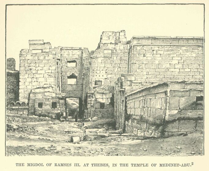
The records of victories graven on the walls of the Theban temples furnish, it is true, a general conception of their appearance, but the notions of them which we should obtain from this source would be of a very confused character had not one of the last of the conquering Pharaohs, Ramses III., taken it into his head to have one built at Thebes itself, to contain within it, in addition to his funerary chapel, accommodation for the attendants assigned to the conduct of his worship. In the Greek and Roman period a portion of this fortress was demolished, but the external wall of defence still exists on the eastern side, together with the gate, which is commanded on the right by a projection of the enclosing-wall, and flanked by two guard-houses, rectangular in shape, and having roofs which jut out about a yard beyond the wall of support. Having passed through these obstacles, we find ourselves face to face with a migdol of cut stone, nearly square in form, with two projecting wings, the court between their loop-holed walls being made to contract gradually from the point of approach by a series of abutments. A careful examination of the place, indeed, reveals more than one arrangement which the limited knowledge of the Egyptians would hardly permit us to expect. We discover, for instance, that the main body of the building is made to rest upon a sloping sub-structure which rises to a height of some sixteen feet.
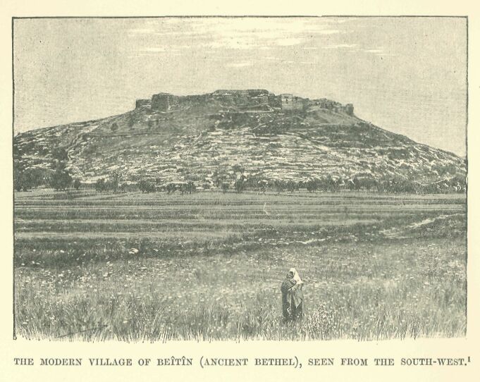
This served two purposes: it increased, in the first place, the strength of the defence against sapping; and in the second, it caused the weapons launched by the enemy to rebound with violence from its inclined surface, thus serving to keep the assailants at a distance. The whole structure has an imposing look, and it must be admitted that the royal architects charged with carrying out their sovereign's idea brought to their task an attention to detail for which the people from whom the plan was borrowed had no capacity, and at the same time preserved the arrangements of their model so faithfully that we can readily realise what it must have been. Transport this migdol of Ramses III. into Asia, plant it upon one of those hills which the Canaanites were accustomed to select as a site for their fortifications, spread out at its base some score of low and miserable hovels, and we have before us an improvised pattern of a village which recalls in a striking manner Zerîn or Beîtîn, or any other small modern town which gathers the dwellings of its fellahin round some central stone building—whether it be a hostelry for benighted travellers, or an ancient castle of the Crusading age.
Drawn by Boudier, from a photograph.
There were on the littoral, to the north of Gaza, two large walled towns, Ascalon and Joppa, in whose roadsteads merchant vessels were accustomed to take hasty refuge in tempestuous weather.* There were to be found on the plains also, and on the lower slopes of the mountains, a number of similar fortresses and villages, such as Iurza, Migdol, Lachish, Ajalon, Shocho, Adora, Aphukîn, Keilah, Gezer, and Ono; and, in the neighbourhood of the roads which led to the fords of the Jordan, Gibeah, Beth-Anoth, and finally Urusalim, our Jerusalem.** A tolerably dense population of active and industrious husbandmen maintained themselves upon the soil.
     * Ascalon was not actually on the sea. Its port, "Maiumas
     Ascalonis," was probably merely a narrow bay or creek, now,
     for a long period, filled up by the sand. Neither the site
     nor the remains of the port have been discovered. The name
     of the town is always spelled in Egyptian with an "s "—
     Askaluna, which gives us the pronunciation of the time. The
     name of Joppa is written Yapu, Yaphu, and the gardens which
     then surrounded the town are mentioned in the Anastasi
     Papyrus I.

     ** Urusalim is mentioned only in the Tel el-Amarna tablets,
     alongside of Kilti or Keilah, Ajalon, and Lachish. The
     remaining towns are noticed in the great lists of Thûtmosis
     III.
The plough which they employed was like that used by the Egyptians and Babylonians, being nothing but a large hoe to which a couple of oxen were harnessed.* The scarcity of rain, except in certain seasons, and the tendency of the rivers to run low, contributed to make the cultivators of the soil experts in irrigation and agriculture. Almost the only remains of these people which have come down ti us consist of indestructible wells and cisterns, or wine and oil presses hollowed out of the rock.**
     * This is the form of plough still employed by the Syrians
     in some places.

     ** Monuments of this kind are encountered at every step in
     Judaea, but it is very difficult to date them. The aqueduct
     of Siloam, which goes back perhaps to the time of Hezekiah.
Fields of wheat and barley extended along the flats of the valleys, broken in upon here and there by orchards, in which the white and pink almond, the apple, the fig, the pomegranate, and the olive flourished side by side.
Drawn by Boudier, from a plate in Chesney.
Jerusalem, possibly in part to be attributed to the reign of Solomon, are the only instances to which anything like a certain date may be assigned. But these are long posterior to the XVIIIth dynasty. Good judges, however, attribute some of these monuments to a very distant period: the masonry of the wells of Beersheba is very ancient, if not as it is at present, at least as it was when it was repaired in the time of the Cæsars; the olive and wine presses hewn in the rock do not all date back to the Roman empire, but many belong to a still earlier period, and modern descriptions correspond with what we know of such presses from the Bible.
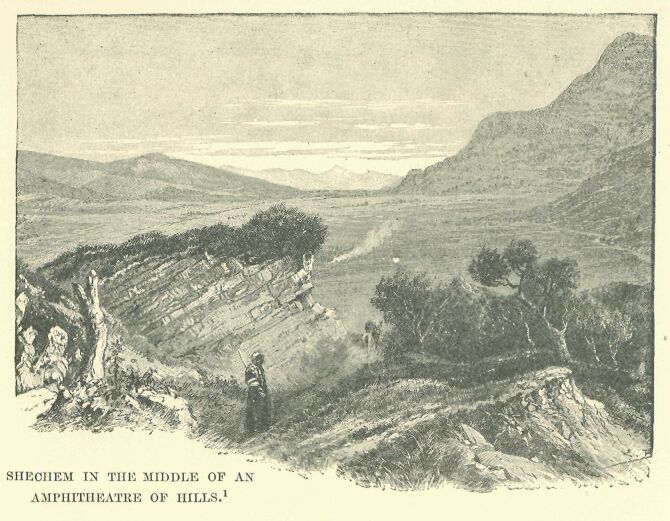
If the slopes of the valley rose too precipitously for cultivation, stone dykes were employed to collect the falling earth, and thus to transform the sides of the hills into a series of terraces rising one above the other. Here the vines, planted in lines or in trellises, blended their clusters with the fruits of the orchard-trees. It was, indeed, a land of milk and honey, and its topographical nomenclature in the Egyptian geographical lists reflects as in a mirror the agricultural pursuits of its ancient inhabitants: one village, for instance, is called Aubila, "the meadow;" while others bear such names as Ganutu, "the gardens;" Magraphut, "the mounds;" and Karman, "the vineyard." The further we proceed towards the north, we find, with a diminishing aridity, the hillsides covered with richer crops, and the valleys decked out with a more luxuriant and warmly coloured vegetation. Shechem lies in an actual amphitheatre of verdure, which is irrigated by countless unfailing streams; rushing brooks babble on every side, and the vapour given off by them morning and evening covers the entire landscape with a luminous haze, where the outline of each object becomes blurred, and quivers in a manner to which we are accustomed in our Western lands.* Towns grew and multiplied upon this rich and loamy soil, but as these lay outside the usual track of the invading hosts—which preferred to follow the more rugged but shorter route leading straight to Carmel across the plain—the records of the conquerors only casually mention a few of them, such as Bîtshaîlu, Birkana, and Dutîna.**
     * Shechem is not mentioned in the Egyptian geographical
     lists, but Max Müller thinks he has discovered it in the
     name of the mountain of Sikima which figures in the
     Anastasi Papyrus, No. 1.

     ** Bîtshaîlu, identified by Chabas with Bethshan, and with
     Shiloh by Mariette and Maspero, is more probably Bethel,
     written Bît-sha-îlu, either with sh, the old relative
     pronoun of the Phoenician, or with the Assyrian sha; on
     the latter supposition one must suppose, as Sayce does, that
     the compiler of the Egyptian lists had before him sources of
     information in the cuneiform character. Birkana appears to
     be the modern Brukin, and Dutîna is certainly Dothain, now
     Tell-Dothân.
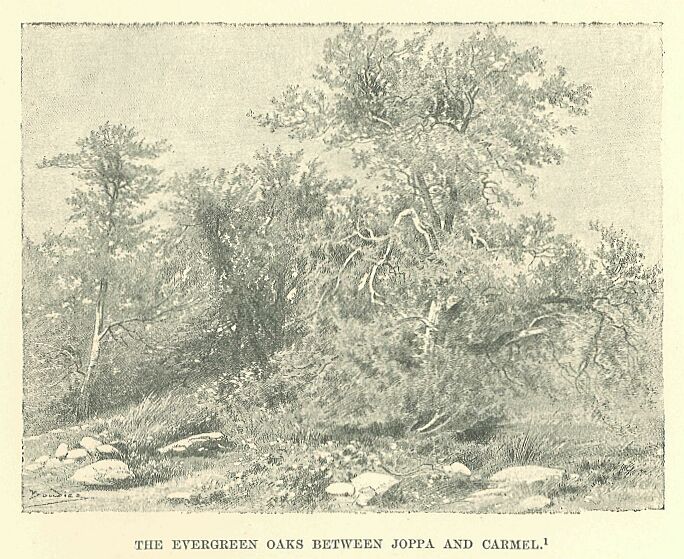
Beyond Ono reddish-coloured sandy clay took the place of the dark and compact loam: oaks began to appear, sparsely at first, but afterwards forming vast forests, which the peasants of our own days have thinned and reduced to a considerable extent. The stunted trunks of these trees are knotted and twisted, and the tallest of them do not exceed some thirty feet in height, while many of them may be regarded as nothing more imposing than large bushes.* Muddy rivers, infested with crocodiles, flowed slowly through the shady woods, spreading out their waters here and there in pestilential swamps. On reaching the seaboard, their exit was impeded by the sands which they brought down with them, and the banks which were thus formed caused the waters to accumulate in lagoons extending behind the dunes. For miles the road led through thickets, interrupted here and there by marshy places and clumps of thorny shrubs. Bands of Shaûsû were accustomed to make this route dangerous, and even the bravest heroes shrank from venturing alone along this route. Towards Aluna the way began to ascend Mount Carmel by a narrow and giddy track cut in the rocky side of the precipice.**
     * The forest was well known to the geographers of the Græco-
     Roman period, and was still in existence at the time of the
     Crusades.

     ** This defile is described at length in the Anastasi
     Papyrus, No. 1, and the terms used by the writer are in
     themselves sufficient evidence of the terror with which the
     place inspired the Egyptians. The annals of Thûtmosis III.
     are equally explicit as to the difficulties which an army
     had to encounter here. I have placed this defile near the
     point which is now called Umm-el-Fahm, and this site seems
     to me to agree better with the account of the expedition of
     Thûtmosis III. than that of Arraneh proposed by Conder.
Beyond the Mount, it led by a rapid descent into a plain covered with corn and verdure, and extending in a width of some thirty miles, by a series of undulations, to the foot of Tabor, where it came to an end. Two side ranges running almost parallel—little Hermon and Glilboa—disposed in a line from east to west, and united by an almost imperceptibly rising ground, serve rather to connect the plain of Megiddo with the valley of the Jordan than to separate them. A single river, the Kishon, cuts the route diagonally—or, to speak more correctly, a single river-bed, which is almost waterless for nine months of the year, and becomes swollen only during the winter rains with the numerous torrents bursting from the hillsides. As the flood approaches the sea it becomes of more manageable proportions, and finally distributes its waters among the desolate lagoons formed behind the sand-banks of the open and wind-swept bay, towered over by the sacred summit of Carmel.*
     * In the lists of Thûtmosis III. we find under No. 48 the
     town of Rosh-Qodshu, the "Sacred Cape," which was evidently
     situated at the end of the mountain range, or probably on
     the site of Haifah; the name itself suggests the veneration
     with which Carmel was invested from the earliest times.
No corner of the world has been the scene of more sanguinary engagements, or has witnessed century after century so many armies crossing its borders and coming into conflict with one another. Every military leader who, after leaving Africa, was able to seize Gaza and Ascalon, became at once master of Southern Syria. He might, it is true, experience some local resistance, and come into conflict with bands or isolated outposts of the enemy, but as a rule he had no need to anticipate a battle before he reached the banks of the Kishon.
Drawn by Boudier, from a pencil sketch by Lortet.
Here, behind a screen of woods and mountain, the enemy would concentrate his forces and prepare resolutely to meet the attack. If the invader succeeded in overcoming resistance at this point, the country lay open to him as far as the Orontes; nay, often even to the Euphrates. The position was too important for its defence to have been neglected. A range of forts, Ibleâm, Taanach, and Megiddo,* drawn like a barrier across the line of advance, protected its southern face, and beyond these a series of strongholds and villages followed one another at intervals in the bends of the valleys or on the heights, such as Shunem, Kasuna, Anaharath, the two Aphuls, Cana, and other places which we find mentioned on the triumphal lists, but of which, up to the present, the sites have not been fixed.
     * Megiddo, the "Legio" of the Roman period, has been
     identified since Robinson's time with Khurbet-Lejûn, and
     more especially with the little mound known by the name of
     Tell-el-Mutesallim. Conder proposed to place its site more
     to the east, in the valley of the Jordan, at Khurbet-el-
     Mujeddah.
Drawn by Faucher-Gudin, from a photograph by Lortet.
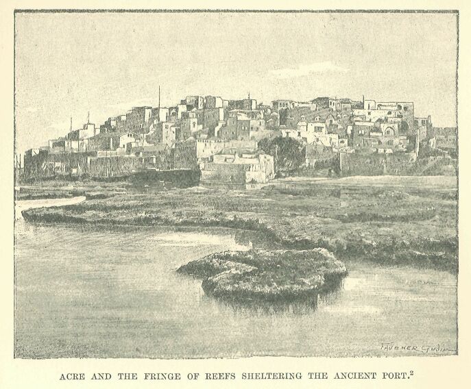
From this point the conqueror had a choice of three routes. One ran in an oblique direction to the west, and struck the Mediterranean near Acre, leaving on the left the promontory of Carmel, with the sacred town, Rosh-Qodshu, planted on its slope.
Drawn by Faucher-Gudin,
from a photograph by Beato.
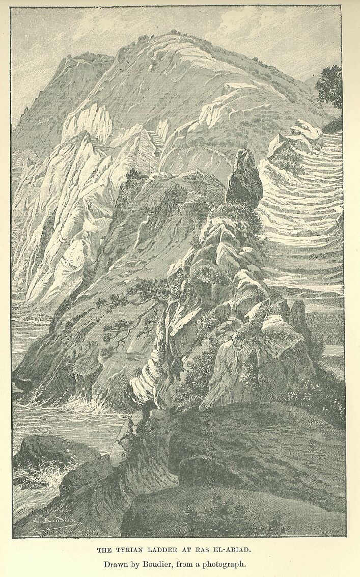
Acre was the first port where a fleet could find safe anchorage after leaving the mouths of the Nile, and whoever was able to make himself master of it had in his hands the key of Syria, for it stood in the same commanding position with regard to the coast as that held by Megiddo in respect of the interior. Its houses were built closely together on a spit of rock which projected boldly into the sea, while fringes of reefs formed for it a kind of natural breakwater, behind which ships could find a safe harbourage from the attacks of pirates or the perils of bad weather. From this point the hills come so near the shore that one is sometimes obliged to wade along the beach to avoid a projecting spur, and sometimes to climb a zig-zag path in order to cross a headland. In more than one place the rock has been hollowed into a series of rough steps, giving it the appearance of a vast ladder.* Below this precipitous path the waves dash with fury, and when the wind sets towards the land every thud causes the rocky wall to tremble, and detaches fragments from its surface. The majority of the towns, such as Aksapu (Ecdippa), Mashal, Lubina, Ushu-Shakhan, lay back from the sea on the mountain ridges, out of the reach of pirates; several, however, were built on the shore, under the shelter of some promontory, and the inhabitants of these derived a miserable subsistence from fishing and the chase. Beyond the Tyrian Ladder Phoenician territory began. The country was served throughout its entire length, from town to town, by the coast road, which turning at length to the right, and passing through the defile formed by the Nahr-el-Kebîr, entered the region of the middle Orontes.
     * Hence the name Tyrian Ladder, which is applied to one of
     these passes, either Ras-en-Nakurah or Ras-el-Abiad.
The second of the roads leading from Megiddo described an almost symmetrical curve eastwards, crossing the Jordan at Beth-shan, then the Jab-bok, and finally reaching Damascus after having skirted at some distance the last of the basaltic ramparts of the Haurân. Here extended a vast but badly watered pasture-land, which attracted the Bedouin from every side, and scattered over it were a number of walled towns, such as Hamath, Magato, Ashtaroth, and Ono-Eepha.*
     * Proof that the Egyptians knew this route, followed even to
     this day in certain circumstances, is furnished by the lists
     of Thûtmosis III., in which the principal stations which it
     comprises are enumerated among the towns given up after the
     victory of Megiddo. Dimasqu was identified with Damascus by
     E. de Rougé, and Astarotu with Ashtarôth-Qarnaim. Hamatu is
     probably Hamath of the Gadarenes; Magato, the Maged of the
     Maccabees, is possibly the present Mukatta; and Ono-Repha,
     Raphôn, Raphana, Arpha of Decapolis, is the modern Er-Rafeh.
Probably Damascus was already at this period the dominant authority over the region watered by these two rivers, as well as over the villages nestling in the gorges of Hermon,—Abila, Helbôn of the vineyards, and Tabrûd,—but it had not yet acquired its renown for riches and power. Protected by the Anti-Lebanon range from its turbulent neighbours, it led a sort of vegetative existence apart from invading hosts, forgotten and hushed to sleep, as it were, in the shade of its gardens.
The third road from Megiddo took the shortest way possible. After crossing the Kishon almost at right angles to its course, it ascended by a series of steep inclines to arid plains, fringed or intersected by green and flourishing valleys, which afforded sites for numerous towns,—Pahira, Merom near Lake Huleh, Qart-Nizanu, Beerotu, and Lauîsa, situated in the marshy district at the head-waters of the Jordan.* From this point forward the land begins to fall, and taking a hollow shape, is known as Coele-Syria, with its luxuriant vegetation spread between the two ranges of the Lebanon. It was inhabited then, as at the time of the Babylonian conquest, by the Amorites, who probably included Damascus also in their domain.**
     * Pahira is probably Safed; Qart-Nizanu, the "flowery city,"
     the Kartha of Zabulon; and Bcerôt, the Berotha of Josephus,
     near Merom. Maroma and Lauîsa, Laisa, have been identified
     with Merom and Laish.

     ** The identification of the country of Amâuru with that of
     the Amorites was admitted from the first. The only doubt was
     as to the locality occupied by these Amorites: the mention
     of Qodshu on the Orontes, in the country of the Amurru,
     showed that Coele-Syria was the region in question. In the
     Tel el-Amarna tablets the name Amurru is applied also to the
     country east of the Phoenician coast, and we have seen that
     there is reason to believe that it was used by the
     Babylonians to denote all Syria. If the name given by the
     cuneiform inscriptions to Damascus and its neighbourhood,
     "Gar-Imirîshu," "Imirîshu," "Imirîsh," really means "the
     Fortress of the Amorites," we should have in this fact a
     proof that this people were in actual possession of the
     Damascene Syria. This must have been taken from them by the
     Hittites towards the XXth century before our era, according
     to Hommel; about the end of the XVIIIth dynasty, according
     to Lenormant. If, on the other hand, the Assyrians read the
     name "Sha-imiri-shu," with the signification, "the town of
     its asses," it is simply a play upon words, and has no
     bearing upon the primitive meaning of the name.
Drawn by Boudier, from a photograph.
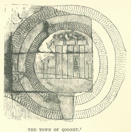
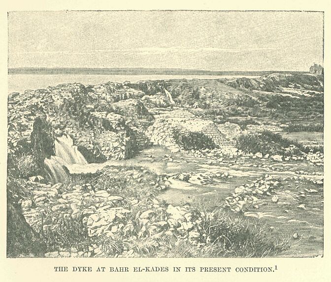
Their capital, the sacred Qodshu, was situated on the left bank of the Orontes, about five miles from the lake which for a long time bore its name, Bahr-el-Kades.* It crowned one of those barren oblong eminences which are so frequently met with in Syria. A muddy stream, the Tannur, flowed, at some distance away, around its base, and, emptying itself into the Orontes at a point a little to the north, formed a natural defence for the town on the west. Its encompassing walls, slightly elliptic in form, were strengthened by towers, and surrounded by two concentric ditches which kept the sapper at a distance.
     * The name Qodshu-Kadesh was for a long time read Uatesh,
     Badesh, Atesh, and, owing to a confusion with Qodi, Ati, or
     Atet. The town was identified by Champollion with Bactria,
     then transferred to Mesopotamia by Bosollini, in the land of
     Omira, which, according to Pliny, was close to the Taurus,
     not far from the Khabur or from the province of Aleppo:
     Osburn tried to connect it with Hadashah (Josh. xv. 21),
     an Amorite town in the southern part of the tribe of Judah;
     while Hincks placed it in Edessa. The reading Kedesh,
     Kadesh, Qodshu, the result of the observations of Lepsius,
     has finally prevailed. Brugsch connected this name with that
     of Bahr el-Kades, a designation attached in the Middle Ages
     to the lake through which the Orontes flows, and placed the
     town on its shores or on a small island on the lake. Thomson
     pointed out Tell Neby-Mendeh, the ancient Laodicea of the
     Lebanon, as satisfying the requirements of the site. Conder
     developed this idea, and showed that all the conditions
     prescribed by the Egyptian texts in regard to Qodshu find
     here, and here alone, their application. The description
     given in the text is based on Conder's observations.
Drawn by Boudier, from a photograph.
A dyke running across the Orontes above the town caused the waters to rise and to overflow in a northern direction, so as to form a shallow lake, which acted as an additional protection from the enemy. Qodshu was thus a kind of artificial island, connected with the surrounding country by two flying bridges, which could be opened or shut at pleasure. Once the bridges were raised and the gates closed, the boldest enemy had no resource left but to arm himself with patience and settle down to a lengthened siege. The invader, fresh from a victory at Megiddo, and following up his good fortune in a forward movement, had to reckon upon further and serious resistance at this point, and to prepare himself for a second conflict. The Amorite chiefs and their allies had the advantage of a level and firm ground for the evolutions of their chariots during the attack, while, if they were beaten, the citadel afforded them a secure rallying-place, whence, having gathered their shattered troops, they could regain their respective countries, or enter, with the help of a few devoted men, upon a species of guerilla warfare in which they excelled.
The road from Damascus led to a point south of Quodshu, while that from Phonicia came right up to the town itself or to its immediate neighbourhood. The dyke of Bahr el-Kades served to keep the plain in a dry condition, and thus secured for numerous towns, among which Hamath stood out pre-eminently, a prosperous existence. Beyond Hamath, and to the left, between the Orontes and the sea, lay the commercial kingdom of Alasia, protected from the invader by bleak mountains.*
     * The site of Alasia, Alashia, was determined from the Tel
     el-Amarna tablets by Maspero. Niebuhr had placed it to the
     west of Cilicia, opposite the island of Eleousa mentioned by
     Strabo. Conder connected it with the scriptural Elishah, and
     W. Max Millier confounds it with Asi or Cyprus.
On the right, between the Orontes and the Balikh, extended the land of rivers, Naharaim. Towns had grown up here thickly,—on the sides of the torrents from the Amanos, along the banks of rivers, near springs or wells—wherever, in fact, the presence of water made culture possible. The fragments of the Egyptian chronicles which have come down to us number these towns by the hundred,* and yet of how many more must the records have perished with the crumbling Theban walls upon which the Pharaohs had their names incised! Khalabu was the Aleppo of our own day,** and grouped around it lay Turmanuna, Tunipa, Zarabu, Nîi, Durbaniti, Nirabu, Sarmata,*** and a score of others which depended upon it, or upon one of its rivals. The boundaries of this portion of the Lower Lotanû have come down to us in a singularly indefinite form, and they must also, moreover, have been subject to continual modifications from the results of tribal conflicts.
     * Two hundred and thirty names belonging to Naharaim are
     still legible on the lists of Thûtmosis III., and a hundred
     others have been effaced from the monument.

     ** Khalabu was identified by Chabas with Khalybôn, the
     modern Aleppo, and his opinion has been adopted by most
     Egyptologists.

     *** Tunipa has been found in Tennib, Tinnab, by Noldoke;
     Zarabu in Zarbi, and Sarmata in Sarmeda, by Tomkins;
     Durbaniti in Deîr el-Banât, the Castrum Puellarum of the
     chroniclers of the Crusades; Nirabu in Nirab, and Tirabu in
     Tereb, now el-Athrib. Nirab is mentioned by Nicholas of
     Damascus. Nîi, long confounded with Nineveh, was identified
     by Lenormant with Ninus Vetus, Membidj, and by Max Millier
     with Balis on the Euphrates: I am inclined to make it Kefer-
     Naya, between Aleppo and Turmanin.
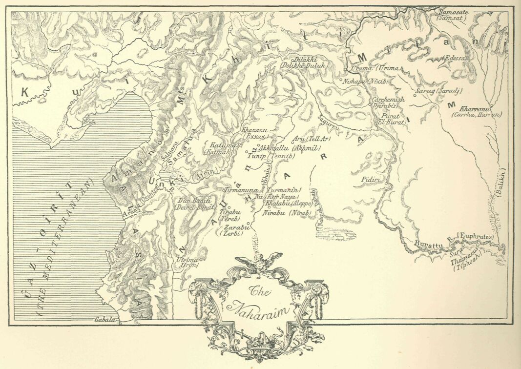
We are at a loss to know whether the various principalities were accustomed to submit to the leadership of a single individual, or whether we are to relegate to the region of popular fancy that Lord of Naharaim of whom the Egyptian scribes made such a hero in their fantastic narratives.*
     * In the "Story of the Predestined Prince" the heroine is
     daughter of the Prince of Naharaim, who seems to exercise
     authority over all the chiefs of the country; as the
     manuscript does not date back further than the XXth dynasty,
     we are justified in supposing that the Egyptian writer had a
     knowledge of the Hittite domination, during which the King
     of the Khâti was actually the ruler of all Naharaim.
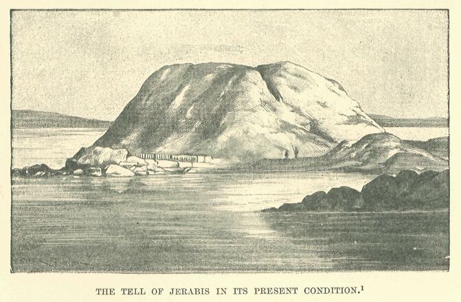
Carchemish represented in this region the position occupied by Megiddo in relation to Kharû, and by Qodshu among the Amorites; that is to say, it was the citadel and sanctuary of the surrounding country. Whoever could make himself master of it would have the whole country at his feet.
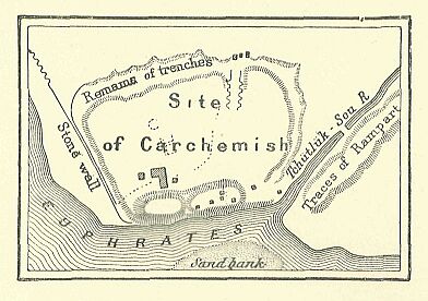
It lay upon the Euphrates, the winding of the river protecting it on its southern and south-eastern sides, while around its northern front ran a deep stream, its defence being further completed by a double ditch across the intervening region. Like Qodshu, it was thus situated in the midst of an artificial island beyond the reach of the battering-ram or the sapper. The encompassing wall, which tended to describe an ellipse, hardly measured two miles in circumference; but the suburbs extending, in the midst of villas and gardens, along the river-banks furnished in time of peace an abode for the surplus population. The wall still rises some five and twenty to thirty feet above the plain. Two mounds divided by a ravine command its north-western side, their summits being occupied by the ruins of two fine buildings—a temple and a palace.* Carchemish was the last stage in a conqueror's march coming from the south.
     * Karkamisha, Gargamish, was from the beginning associated
     with the Carchemish of the Bible; but as the latter was
     wrongly identified with Circesium, it was naturally located
     at the confluence of the Khabur with the Euphrates. Hincks
     fixed the site at Rum-Kaleh. G. Rawlinson referred it
     cursorily to Hierapolis-Mabog, which position Maspero
     endeavoured to confirm. Finzi, and after him G. Smith,
     thought to find the site at Jerabis, the ancient Europos,
     and excavations carried on there by the English have brought
     to light in this place Hittite monuments which go back in
     part to the Assyrian epoch. This identification is now
     generally accepted, although there is still no direct proof
     attainable, and competent judges continue to prefer the site
     of Membij. I fall in with the current view, but with all
     reserve.
Reproduced by Faucher-Gudin, from a cut in the Graphic.
For an invader approaching from the east or north it formed his first station. He had before him, in fact, a choice of the three chief fords for crossing the Euphrates. That of Thapsacus, at the bend of the river where it turns eastward to the Arabian plain, lay too far to the south, and it could be reached only after a march through a parched and desolate region where the army would run the risk of perishing from thirst.
Drawn by Faucher-Gudin,
from a photograph.
For an invader proceeding from Asia Minor, or intending to make his way through the defiles of the Taurus, Samosata offered a convenient fording-place; but this route would compel the general, who had Naharaim or the kingdoms of Chaldæa in view, to make a long detour, and although the Assyrians used it at a later period, at the time of their expeditions to the valleys of the Halys, the Egyptians do not seem ever to have travelled by this road. Carchemish, the place of the third ford, was about equally distant from Thapsacus and Samosata, and lay in a rich and fertile province, which was so well watered that a drought or a famine would not be likely to enter into the expectations of its inhabitants. Hither pilgrims, merchants, soldiers, and all the wandering denizens of the world were accustomed to direct their steps, and the habit once established was perpetuated for centuries. On the left bank of the river, and almost opposite Carchemish, lay the region of Mitânni,* which was already occupied by a people of a different race, who used a language cognate, it would seem, with the imperfectly classified dialects spoken by the tribes of the Upper Tigris and Upper Euphrates.** Harran bordered on Mitânni, and beyond Harran one may recognise, in the vaguely defined Singar, Assur, Arrapkha, and Babel, states that arose out of the dismemberment of the ancient Chaldæan Empire.***
     * Mitânni is mentioned on several Egyptian monuments; but
     its importance was not recognised until after the discovery
     of the Tel el-Amarna tablets and of its situation. The fact
     that a letter from the Prince of Mitânni is stated in a
     Hieratic docket to have come from Naharaim has been used as
     a proof that the countries were identical; I have shown that
     the docket proves only that Mitânni formed a part of
     Naharaim. It extended over the province of Edessa and
     Harran, stretching out towards the sources of the Tigris.
     Niebuhr places it on the southern slope of the Masios, in
     Mygdonia; Th. Reinach connects it with the Matiôni, and asks
     whether this was not the region occupied by this people
     before their emigration towards the Caspian.

     ** Several of the Tel el-Amarna tablets are couched in this
     language.

     *** These names were recognised from the first in the
     inscriptions of Thûtmosis III. and in those of other
     Pharaohs of the XVIIIth and XIXth dynasties.
The Carchemish route was, of course, well known to caravans, but armed bodies had rarely occasion to make use of it. It was a far cry from Memphis to Carchemish, and for the Egyptians this town continued to be a limit which they never passed, except incidentally, when they had to chastise some turbulent tribe, or to give some ill-guarded town to the flames.*
     * A certain number of towns mentioned in the lists of
     Thûtmosis III. were situated beyond the Euphrates, and they
     belonged some to Mitânni and some to the regions further
     away.
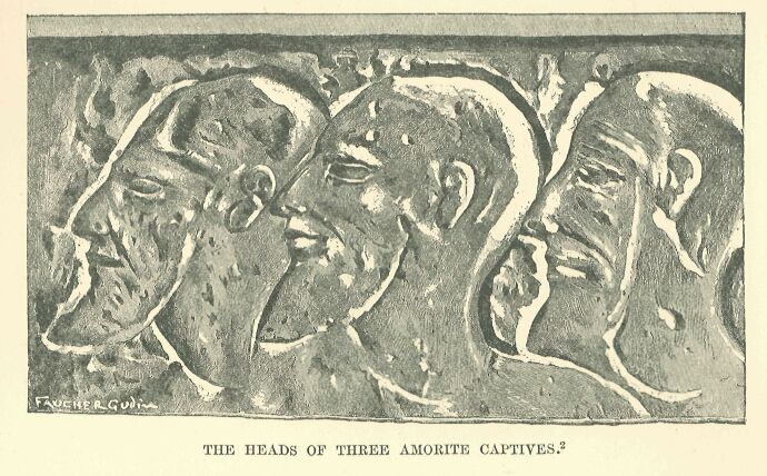
Drawn by Faucher-Gudin,
from a photograph.
It would be a difficult task to define with any approach to accuracy the distribution of the Canaanites, Amorites, and Aramæans, and to indicate the precise points where they came into contact with their rivals of non-Semitic stock. Frontiers between races and languages can never be very easily determined, and this is especially true of the peoples of Syria. They are so broken up and mixed in this region, that even in neighbourhoods where one predominant tribe is concentrated, it is easy to find at every step representatives of all the others. Four or five townships, singled out at random from the middle of a province, would often be found to belong to as many different races, and their respective inhabitants, while living within a distance of a mile or two, would be as great strangers to each other as if they were separated by the breadth of a continent.
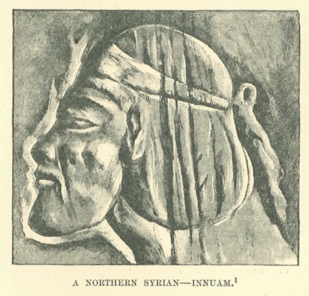
Drawn by Faucher-Gudin, from a photograph.
It would appear that the breaking up of these populations had not been carried so far in ancient as in modern times, but the confusion must already have been great if we are to judge from the number of different sites where we encounter evidences of people of the same language and blood. The bulk of the Khâti had not yet departed from the Taurus region, but some stray bands of them, carried away by the movement which led to the invasion of the Hyksôs, had settled around Hebron, where the rugged nature of the country served to protect them from their neighbours.*
     * In very early times they are described as dwelling near
     Hebron or in the mountains of Judah. Since we have learned
     from the Egyptian and Assyrian monuments that the Khâti
     dwelt in Northern Syria, the majority of commentators have
     been indisposed to admit the existence of southern Hittites;
     this name, it is alleged, having been introduced into the
     Biblical around text through a misconception of the original
     documents, where the term Hittite was the equivalent of
     Canaanite.
The Amorites* had their head-quarters Qodshul in Coele-Syria, but one section of them had taken up a position on the shores of the Lake of Tiberias in Galilee, others had established themselves within a short distance of Jaffa** on the Mediterranean, while others had settled in the neighbourhood of the southern Hittites in such numbers that their name in the Hebrew Scriptures was at times employed to designate the western mountainous region about the Dead Sea and the valley of the Jordan. Their presence was also indicated on the table-lands bordering the desert of Damascus, in the districts frequented by Bedouin of the tribe of Terah, Ammon and Moab, on the rivers Yarmuk and Jabbok, and at Edrei and Heshbon.***
     * Ed. Meyer has established the fact that the term Amorite,
     as well as the parallel word Canaanite, was the designation
     of the inhabitants of Palestine before the arrival of the
     Hebrews: the former belonged to the prevailing tradition in
     the kingdom of Israel, the latter to that which was current
     in Judah. This view confirms the conclusion which may be
     drawn from the Egyptian monuments as to the power of
     expansion and the diffusion of the people.

     ** These were the Amorites which the tribe of Dan at a later
     period could not dislodge from the lands which had been
     allotted to them.

     *** This was afterwards the domain of Sihon, King of the
     Amorites, and that of Og.
The fuller, indeed, our knowledge is of the condition of Syria at the time of the Egyptian conquest, the more we are forced to recognise the mixture of races therein, and their almost infinite subdivisions. The mutual jealousies, however, of these elements of various origin were not so inveterate as to put an obstacle in the way, I will not say of political alliances, but of daily intercourse and frequent contracts. Owing to intermarriages between the tribes, and the continual crossing of the results of such unions, peculiar characteristics were at length eliminated, and a uniform type of face was the result. From north to south one special form of countenance, that which we usually call Semitic, prevailed among them.
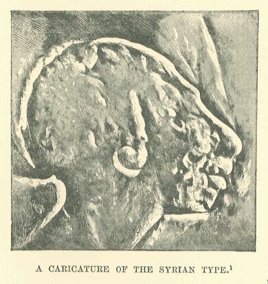
Drawn by Faucher-Gudin,
from a photograph.
The Syrian and Egyptian monuments furnish us everywhere, under different ethnical names, with representations of a broad-shouldered people of high stature, slender-figured in youth, but with a fatal tendency to obesity in old age. Their heads are large, somewhat narrow, and artificially flattened or deformed, like those of several modern tribes in the Lebanon. Their high cheek-bones stand out from their hollow cheeks, and their blue or black eyes are buried under their enormous eyebrows. The lower part of the face is square and somewhat heavy, but it is often concealed by a thick and curly beard. The forehead is rather low and retreating, while the nose has a distinctly aquiline curve. The type is not on the whole so fine as the Egyptian, but it is not so heavy as that of the Chaldæans in the time of Gudea. The Theban artists have represented it in their battle-scenes, and while individualising every soldier or Asiatic prisoner with a happy knack so as to avoid monotony, they have with much intelligence impressed upon all of them the marks of a common parentage.
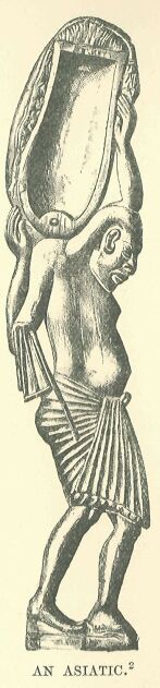
Drawn by Faucher-Gudin,
from the original
wooden object.
One feels that the artists must have recognised them as belonging to one common family. They associated with their efforts after true and exact representation a certain caustic humour, which impelled them often to substitute for a portrait a more or less jocose caricature of their adversaries. On the walls of the Pylons, and in places where the majesty of a god restrained them from departing too openly from their official gravity, they contented themselves with exaggerating from panel to panel the contortions and pitiable expressions of the captive chiefs as they followed behind the triumphal chariot of the Pharaoh on his return from his Syrian campaigns.*
     * An illustration of this will be found in the line of
     prisoners, brought by Seti I. from his great Asiatic
     campaign, which is depicted on the outer face of the north
     wall of the hypostyle at Karnak.
Where religious scruples offered no obstacle they abandoned themselves to the inspiration of the moment, and gave themselves freely up to caricature. It is an Amorite or Canaanite—that thick-lipped, flat-nosed slave, with his brutal lower jaw and smooth conical skull—who serves for the handle of a spoon in the museum of the Louvre. The stupefied air with which he trudges under his burden is rendered in the most natural manner, and the flattening to which his forehead had been subjected in infancy is unfeelingly accentuated. The model which served for this object must have been intentionally brutalised and disfigured in order to excite the laughter of Pharaoh's subjects.*
     * Dr. Regnault thinks that the head was artificially
     deformed in infancy: the bandage necessary to effect it must
     have been applied very low on the forehead in front, and to
     the whole occiput behind. If this is the case, the instance
     is not an isolated one, for a deformation of a similar
     character is found in the case of the numerous Semites
     represented on the tomb of Rakhmiri: a similar practice
     still obtains in certain parts of modern Syria.
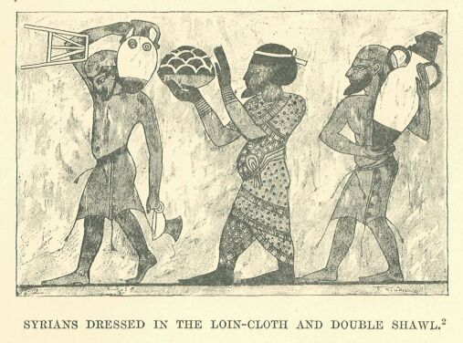
Drawn by Faucher-Gudin, from a photograph by Insinger.
The idea of uniformity with which we are impressed when examining the faces of these people is confirmed and extended when we come to study their costumes. Men and women—we may say all Syrians according to their condition of life—had a choice between only two or three modes of dress, which, whatever the locality, or whatever the period, seemed never to change. On closer examination slight shades of difference in cut and arrangement may, however, be detected, and it may be affirmed that fashion ran even in ancient Syria through as many capricious evolutions as with ourselves; but these variations, which were evident to the eyes of the people of the time, are not sufficiently striking to enable us to classify the people, or to fix their date. The peasants and the lower class of citizens required no other clothing than a loin-cloth similar to that of the Egyptians,* or a shirt of a yellow or white colour, extending below the knees, and furnished with short sleeves. The opening for the neck was cruciform, and the hem was usually ornamented with coloured needlework or embroidery. The burghers and nobles wore over this a long strip of cloth, which, after passing closely round the hips and chest, was brought up and spread over the shoulders as a sort of cloak. This was not made of the light material used in Egypt, which offered no protection from cold or rain, but was composed of a thick, rough wool, like that employed in Chaldæa, and was commonly adorned with stripes or bands of colour, in addition to spots and other conspicuous designs.
     * The Asiatic loin-cloth differs from the Egyptian in having
     pendent cords; the Syrian fellahin still wear it when at
     work.
Rich and fashionable folk substituted for this cloth two large shawls—one red and the other blue—in which they dexterously arrayed themselves so as to alternate the colours: a belt of soft leather gathered the folds around the figure. Red morocco buskins, a soft cap, a handkerchief, a kejfîyeh confined by a fillet, and sometimes a wig after the Egyptian fashion, completed the dress.
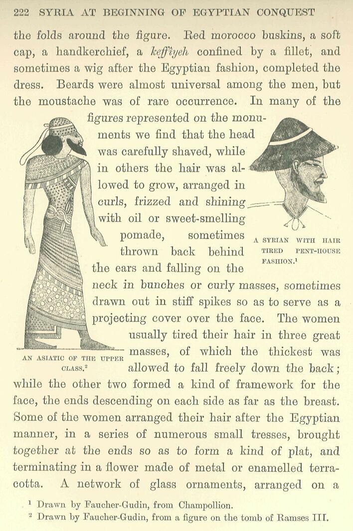
Drawn by Faucher-Gudin, from a figure on the tomb of Ramses III.
Beards were almost universal among the men, but the moustache was of rare occurrence. In many of the figures represented on the monuments we find that the head was carefully shaved, while in others the hair was allowed to grow, arranged in curls, frizzed and shining with oil or sweet-smelling pomade, sometimes thrown back behind the ears and falling on the neck in bunches or curly masses, sometimes drawn out in stiff spikes so as to serve as a projecting cover over the face.
The women usually tired their hair in three great masses, of which the thickest was allowed to fall freely down the back; while the other two formed a kind of framework for the face, the ends descending on each side as far as the breast. Some of the women arranged their hair after the Egyptian manner, in a series of numerous small tresses, brought together at the ends so as to form a kind of plat, and terminating in a flower made of metal or enamelled terracotta. A network of glass ornaments, arranged on a semicircle of beads, or on a background of embroidered stuff, was frequently used as a covering for the top of the head.*
     * Examples of Syrian feminine costume are somewhat rare on
     the Egyptian monuments. In the scenes of the capturing of
     towns we see a few. Here the women are represented on the
     walls imploring the mercy of the besieger. Other figures are
     those of prisoners being led captive into Egypt.
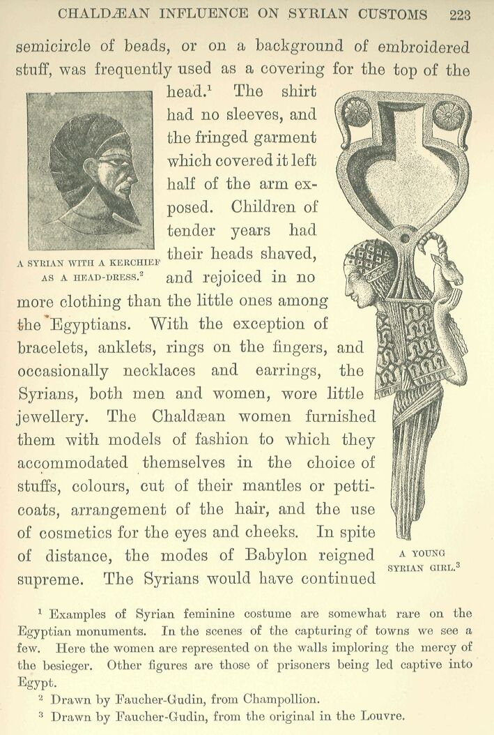
The shirt had no sleeves, and the fringed garment which covered it left half of the arm exposed. Children of tender years had their heads shaved, as a head-dress, and rejoiced in no more clothing than the little ones among the Egyptians. With the exception of bracelets, anklets, rings on the fingers, and occasionally necklaces and earrings, the Syrians, both men and women, wore little jewellery. The Chaldæa women furnished them with models of fashion to which they accommodated themselves in the choice of stuffs, colours, cut of their mantles or petticoats, arrangement of the hair, and the use of cosmetics for the eyes and cheeks. In spite of distance, the modes of Babylon reigned supreme. The Syrians would have continued to expose their right shoulder to the weather as long as it pleased the people of the Lower Euphrates to do the same; but as soon as the fashion changed in the latter region, and it became customary to cover the shoulder, and to wrap the upper part of the person in two or three thicknesses of heavy wool, they at once accommodated themselves to the new mode, although it served to restrain the free motion of the body. Among the upper classes, at least, domestic arrangements were modelled upon the fashions observed in the palaces of the nobles of Car-chemish or Assur: the same articles of toilet, the same ranks of servants and scribes, the same luxurious habits, and the same use of perfumes were to be found among both.*
     * An example of the fashion of leaving the shoulder bare is
     found even in the XXth dynasty. The Tel el-Amarna tablets
     prove that, as far as the scribes were concerned, the
     customs and training of Syria and Chaldæa were identical.
     The Syrian princes are there represented as employing the
     cuneiform character in their correspondence, being
     accompanied by scribes brought up after the Chaldæan manner.
     We shall see later on that the king of the Khati, who
     represented in the time of Ramses II. the type of an
     accomplished Syrian, had attendants similar to those of the
     Chaldæan kings.
From all that we can gather, in short, from the silence as well as from the misunderstandings of the Egyptian chroniclers, Syria stands before us as a fruitful and civilized country, of which one might be thankful to be a native, in spite of continual wars and frequent revolutions.
The religion of the Syrians was subject to the same influences as their customs; we are, as yet, far from being able to draw a complete picture of their theology, but such knowledge as we do possess recalls the same names and the same elements as are found in the religious systems of Chaldæa. The myths, it is true, are still vague and misty, at least to our modern ideas: the general characteristics of the principal divinities alone stand out, and seem fairly well defined. As with the other Semitic races, the deity in a general sense, the primordial type of the godhead, was called El or Ilû, and his feminine counterpart Ilât, but we find comparatively few cities in which these nearly abstract beings enjoyed the veneration of the faithful.* The gods of Syria, like those of Egypt and of the countries watered by the Euphrates, were feudal princes distributed over the surface of the earth, their number corresponding with that of the independent states. Each nation, each tribe, each city, worshipped its own lord—Adoni** —or its master—Baal*** —and each of these was designated by a special title to distinguish him from neighbouring Baalîm, or masters.
     * The frequent occurrence of the term Ilû or El in names
     of towns in Southern Syria seems to indicate pretty
     conclusively that the inhabitants of these countries used
     this term by preference to designate their supreme god.
     Similarly we meet with it in Aramaic names, and later on
     among the Nabathseans; it predominates at Byblos and Berytus
     in Phoenicia and among the Aramaic peoples of North Syria;
     in the Samalla country, for instance, during the VIIIth
     century B.C.

     ** The extension of this term to Syrian countries is proved
     in the Israelitish epoch by Canaanitish names, such as
     Adonizedek and Adonibezek, or Jewish names such as Adonijah,
     Adonikam, Adoniram-Adoram.

     *** Movers tried to prove that there was one particular god
     named Baal, and his ideas, popularised in Prance by M. de
     Vogiié, prevailed for some time: since then scholars have
     gone back to the view of Münter and of the writers at the
     beginning of this century, who regarded the term Baal as a
     common epithet applicable to all gods.
The Baal who ruled at Zebub was styled "Master of Zebub," or Baal-Zebub;* and the Baal of Hermon, who was an ally of Gad, goddess of fortune, was sometimes called Baal-Hermon, or "Master of Hermon," sometimes Baal-G-ad, or "Master of Gad;"** the Baal of Shechem, at the time of the Israelite invasion, was "Master of the Covenant"—Baal-Berîth—doubtless in memory of some agreement which he had concluded with his worshippers in regard to the conditions of their allegiance.***
     * Baal-Zebub was worshipped at Ekxon during the Philistine
     supremacy.

     ** The mountain of Baal-Hermon is the mountain of Baniâs,
     where the Jordan has one of its sources, and the town of
     Baal-Hermon is Baniâs itself. The variant Baal-Gad occurs
     several times in the Biblical books.

     *** Baal-Berith, like Baal-Zebub, only occurs, so far as we
     know at present, in the Hebrew Scriptures, where, by the
     way, the first element, Baal, is changed to El, El-Berith.
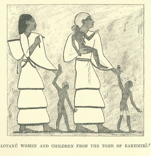
     Drawn by Faucher-Gudin, from coloured sketches by Prisse
     d'Avennes.
The prevalent conception of the essence and attributes of these deities was not the same in all their sanctuaries, but the more exalted among them were regarded as personifying the sky in the daytime or at night, the atmosphere, the light,* or the sun, Shamash, as creator and prime mover of the universe; and each declared himself to be king—melek—over the other gods.** Bashuf represented the lightning and the thunderbolt;*** Shalmân, Hadad, and his double Bimmôn held sway over the air like the Babylonian.
     * This appears under the name Or or Ur in the Samalla
     inscriptions of the VIIIth century B.C.; it is, so far, a
     unique instance among the Semites.

     ** We find the term applied in the Bible to the national god
     of the Ammonites, under the forms Moloch, Molech, Mikôm,
     Milkâm, and especially with the article, Ham-molek; the
     real name hidden beneath this epithet was probably Amnôn or
     Ammân, and, strictly speaking, the God Moloch only exists
     in the imagination of scholars. The epithet was used among
     the Oanaanites in the name Melchizedek, a similar form to
     Adonizedek, Abimelech, Ahimelech; it was in current use
     among the Phoenicians, in reference to the god of Tyre,
     Melek-Karta or Melkarth, and in many proper names, such as
     Melekiathon, Baalmelek, Bodmalek, etc., not to mention the
     god Milichus worshipped in Spain, who was really none other
     than Melkarth.

     *** Resheph has been vocalised Rashuf in deference to the
     Egyptian orthography Rashupu. It was a name common to a
     whole family of lightning and storm-gods, and M. de Rougé
     pointed out long ago the passage in the Great Inscription of
     Ramses III. at Medinet-Habu, in which the soldiers who man
     the chariots are compared to the Rashupu; the Rabbinic
     Hebrew still employs this plural form in the sense of
     "demons." The Phoenician inscriptions contain references to
     several local Rashufs; the way in which this god is coupled
     with the goddess Qodshu on the Egyptian stelæ leads me to
     think that, at the epoch now under consideration, he was
     specially worshipped by the Amorites, just as his equivalent
     Hadad was by the inhabitants of Damascus, neighbours of the
     Amorites, and perhaps themselves Amorites.
Rammânu;* Dagon, patron god of fishermen and husbandmen, seems to have watched over the fruitfulness of the sea and the land.** We are beginning to learn the names of the races whom they specially protected: Rashuf the Amorites, Hadad and Rimmon the Aramæans of Damascus, Dagon the peoples of the coast between Ashkelon and the forest of Carmel. Rashûf is the only one whose appearance is known to us. He possessed the restless temperament usually attributed to the thunder-gods, and was, accordingly, pictured as a soldier armed with javelin and mace, bow and buckler; a gazelle's head with pointed horns surmounts his helmet, and sometimes, it may be, serves him as a cap.
     * Hadad and Rimmon are represented in Assyrio-Chaldæan by
     one and the same ideogram, which may be read either Dadda-
     Hadad or Eammânu. The identity of the expressions employed
     shows how close the connection between the two divinities
     must have been, even if they were not similar in all
     respects; from the Hebrew writings we know of the temple of
     Rimmon at Damascus (2 Kings v. 18) and that one of the
     kings of that city was called Tabrimmôn = "llimmon is good"
     (1 Kings xv. 18), while Hadad gave his name to no less
     than ten kings of the same city. Even as late as the Græco-
     Roman epoch, kingship over the other gods was still
     attributed both to Rimmon and to Hadad, but this latter was
     identified with the sun.

     ** The documents which we possess in regard to Dagon date
     from the Hebrew epoch, and represent him as worshipped by
     the Philistines. We know, however, from the Tel el-Amarna
     tablets, of a Dagantakala, a name which proves the presence
     of the god among the Canaanites long before the Philistine
     invasion, and we find two Beth-Dagons—one in the plain of
     Judah, the other in the tribe of Asher; Philo of Byblos
     makes Dagon a Phoenician deity, and declares him to be the
     genius of fecundity, master of grain and of labour. The
     representation of his statue which appears on the Græco-
     Roman coins of Abydos, reminds us of the fish-god of
     Chaldæa.
Each god had for his complement a goddess, who was proclaimed "mistress" of the city, Baalat, or "queen," Milkat, of heaven, just as the god himself was recognised as "master" or "king."* As a rule, the goddess was contented with the generic name of Astartê; but to this was often added some epithet, which lent her a distinct personality, and prevented her from being confounded with the Astartês of neighbouring cities, her companions or rivals.**
     * Among goddesses to whom the title "Baalat "was referred,
     we have the goddess of Byblos, Baalat-Gebal, also the
     goddess of Berytus, Baalat-Berîth, or Beyrut. The epithet
     "queen of heaven "is applied to the Phoenician Astartê by
     Hebrew (Jer. vii. 18, xliv. 18-29) and classic writers.
     The Egyptians, when they adopted these Oanaanitish
     goddesses, preserved the title, and called each of them
     nibît pit, "lady of heaven." In the Phoenician inscriptions
     their names are frequently preceded by the word Rabbat:
     rabbat Baalat-Gebal, "(my) lady Baalat-Gebal."

     ** The Hebrew writers frequently refer to the Canaanite
     goddesses by the general title "the Ashtarôth" or "Astartês,"
     and a town in Northern Syria bore the significant name of
     Istarâti = "the Ishtars, the Ashtarôth," a name which finds
     a parallel in Anathôth = "the Anats," a title assumed by a
     town of the tribe of Benjamin; similarly, the Assyrio-
     Chaldæans called their goddesses by the plural of Ishtar.
     The inscription on an Egyptian amulet in the Louvre tells us
     of a personage of the XXth dynasty, who, from his name,
     Rabrabîna, must have been of Syrian origin, and who styled
     himself "Prophet of the Astartês," Honnutir Astiratu.
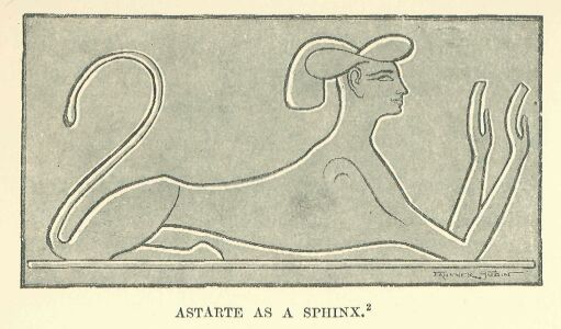
     Drawn by Faucher-Gudin, from a copy of an original in chased
     gold.
Thus she would be styled the "good" Astartê, Ashtoreth Naamah, or the "horned" Astartê, Ashtoreth Qarnaîm, because of the lunar crescent which appears on her forehead, as a sort of head-dress.* She was the goddess of good luck, and was called Gad;** she was Anat,*** or Asîti,**** the chaste and the warlike.
     * The two-horned Astartê gave her name to a city beyond the
     Jordan, of which she was, probably, the eponymous goddess:
     (Gen xiv. 5) she would seem to be represented on the curious
     monument called by the Arabs "the stone of Job," which was
     discovered by M. Schumacher in the centre of the Hauran. It
     was an analogous goddess whom the Egyptians sometimes
     identified with their Hâthor, and whom they represented as
     crowned with a crescent.

     ** Gad, the goddess of fortune, is mainly known to us in
     connection with the Aramæans; we find mention made of her by
     the Hebrew writers, and geographical names, such as Baal-Gad
     and Migdol-Gad, prove that she must have been worshipped at
     a very early date in the Canaanite countries.

     *** Anat, or Anaîti, or Aniti, has been found in a
     Phoenician inscription, which enables us to reconstruct the
     history of the goddess. Her worship was largely practised
     among the Canaanites, as is proved by the existence in the
     Hebrew epoch of several towns, such as Beth-Anath, Beth-
     Anoth, Anathôth; at least one of which, Bît-Anîti, is
     mentioned in the Egyptian geographical lists. The appearance
     of Anat-Anîti is known to us, as she is represented in
     Egyptian dress on several stelæ of the XIXth and XXth
     dynasties. Her name, like that of Astartê, had become a
     generic term, in the plural form Anathôth, for a whole group
     of goddesses.

     **** Asîti is represented at Radesieh, on a stele of the
     time of Seti I.; she enters into the composition of a
     compound name, Asîtiiàkhûrû (perhaps "the goddess of Asiti
     is enflamed with anger "), which we find on a monument in
     the Vienna Museum. W. Max Müller makes her out to have been
     a divinity of the desert, and the place in which the picture
     representing her was found would seem to justify this
     hypothesis; the Egyptians connected her, as well as the
     other Astartês, with Sit-Typhon, owing to her cruel and
     warlike character.
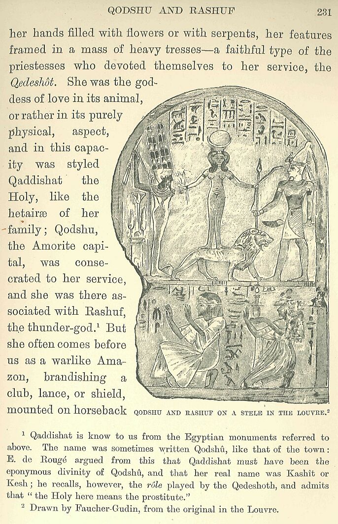
The statues sometimes represent her as a sphinx with a woman's head, but more often as a woman standing on a lion passant, either nude, or encircled round the hips by merely a girdle, her hands filled with flowers or with serpents, her features framed in a mass of heavy tresses—a faithful type of the priestesses who devoted themselves to her service, the Qedeshôt. She was the goddess of love in its animal, or rather in its purely physical, aspect, and in this capacity was styled Qaddishat the Holy, like the hetairæ of her family; Qodshu, the Amorite capital, was consecrated to her service, and she was there associated with Rashuf, the thunder-god.*
     * Qaddishat is know to us from the Egyptian monuments
     referred to above. The name was sometimes written Qodshû,
     like that of the town: E. de Bougé argued from this that
     Qaddishat must have been the eponymous divinity of Qodshû,
     and that her real name was Kashit or Kesh; he recalls,
     however, the rôle played by the Qedeshoth, and admits that
     "the Holy here means the prostitute."
But she often comes before us as a warlike Amazon, brandishing a club, lance, or shield, mounted on horseback like a soldier, and wandering through the desert in quest of her prey.* This dual temperament rendered her a goddess of uncertain attributes and of violent contrasts; at times reserved and chaste, at other times shameless and dissolute, but always cruel, always barren, for the countless multitude of her excesses for ever shut her out from motherhood: she conceives without ceasing, but never brings forth children.** The Baalim and Astartês frequented by choice the tops of mountains, such as Lebanon, Carmel, Hermon, or Kasios:*** they dwelt near springs, or hid themselves in the depths of forests.**** They revealed themselves to mortals through the heavenly bodies, and in all the phenomena of nature: the sun was a Baal, the moon was Astartê, and the whole host of heaven was composed of more or less powerful genii, as we find in Chaldæa.
     * A fragment of a popular tale preserved in the British
     Museum, and mentioned by Birch, seems to show us Astartê in
     her character of war-goddess, and the sword of Astartê is
     mentioned by Chabas. A bas-relief at Edfû represents her
     standing upright in her chariot, drawn by horses, and
     trampling her enemies underfoot: she is there identified
     with Sokhît the warlike, destroyer of men.

     ** This conception of the Syrian goddesses had already
     become firmly established at the period with which we are
     dealing, for an Egyptian magical formula defines Anîti and
     Astartê as "the great goddesses who conceiving do not bring
     forth young, for the Horuses have sealed them and Sit hath
     established them."

     *** The Baal of Lebanon is mentioned in an archaic
     Phoenician inscription, and the name "Holy Cape" (Rosh-
     Qodshu), borne in the time of Thûtmosis III. either by
     Haifa or by a neighbouring town, proves that Carmel was held
     sacred as far back as the Egyptian epoch. Baal-Hermon has
     already been mentioned.

     **** The source of the Jordan, near Baniâs, was the seat of
     a Baal whom the Greeks identified with Pan. This was
     probably the Baal-Gad who often lent his name to the
     neighbouring town of Baal-Hermon: many of the rivers of
     Phoenicia were called after the divinities worshipped in the
     nearest city, e.g. the Adonis, the Bêlos, the Asclepios, the
     Damûras.
They required that offerings and prayers should be brought to them at the high places,* but they were also pleased—and especially the goddesses—to lodge in trees; tree-trunks, sometimes leafy, sometimes bare and branchless (ashêrah), long continued to be living emblems of the local Astartês among the peoples of Southern Syria. Side by side with these plant-gods we find everywhere, in the inmost recesses of the temples, at cross-roads, and in the open fields, blocks of stone hewn into pillars, isolated boulders, or natural rocks, sometimes of meteoric origin, which were recognised by certain mysterious marks to be the house of the god, the Betyli or Beth-els in which he enclosed a part of his intelligence and vital force.
     * These are the "high places" (bamôth) so frequently
     referred to by the Hebrew prophets, and which we find in the
     country of Moab, according to the Mesha inscription, and in
     the place-name Bamoth-Baal; many of them seem to have served
     for Canaanitish places of worship before they were resorted
     to by the children of Israel.
The worship of these gods involved the performance of ceremonies more bloody and licentious even than those practised by other races. The Baalim thirsted after blood, nor would they be satisfied with any common blood such as generally contented their brethren in Chaldæa or Egypt: they imperatively demanded human as well as animal sacrifices. Among several of the Syrian nations they had a prescriptive right to the firstborn male of each family;* this right was generally commuted, either by a money payment or by subjecting the infant to circumcision.**
     * This fact is proved, in so far as the Hebrew people is
     concerned, by the texts of the Pentateuch and of the
     prophets; amongst the Moabites also it was his eldest son
     whom King Mosha took to offer to his god. We find the same
     custom among other Syrian races: Philo of Byblos tells us,
     in fact, that El-Kronos, god of Byblos, sacrificed his
     firstborn son and set the example of this kind of offering.

     ** Redemption by a payment in money was the case among the
     Hebrews, as also the substitution of an animal in the place
     of a child; as to redemption by circumcision, cf. the story
     of Moses and Zipporah, where the mother saves her son from
     Jahveh by circumcising him. Circumcision was practised among
     the Syrians of Palestine in the time of Herodotus.
At important junctures, however, this pretence of bloodshed would fail to appease them, and the death of the child alone availed. Indeed, in times of national danger, the king and nobles would furnish, not merely a single victim, but as many as the priests chose to demand.* While they were being burnt alive on the knees of the statue, or before the sacred emblem, their cries of pain were drowned by the piping of flutes or the blare of trumpets, the parents standing near the altar, without a sign of pity, and dressed as for a festival: the ruler of the world could refuse nothing to prayers backed by so precious an offering, and by a purpose so determined to move him. Such sacrifices were, however, the exception, and the shedding of their own blood by his priests sufficed, as a rule, for the daily wants of the god. Seizing their knives, they would slash their arms and breasts with the view of compelling, by this offering of their own persons, the good will of the Baalim.**
     * If we may credit Tertullian, the custom of offering up
     children as sacrifices lasted down to the proconsulate of
     Tiberius.

     ** Cf., for the Hebraic epoch, the scene where the priests
     of Baal, in a trial of power with Elijah before Ahab,
     offered up sacrifices on the highest point of Carmel, and
     finding that their offerings did not meet with the usual
     success, "cut themselves... with knives and lancets till the
     blood gushed out upon them."
The Astartês of all degrees and kinds were hardly less cruel; they imposed frequent flagellations, self-mutilation, and sometimes even emasculation, on their devotees. Around the majority of these goddesses was gathered an infamous troop of profligates (kedeshîm), "dogs of love" (kelabîm), and courtesans (kedeshôt). The temples bore little resemblance to those of the regions of the Lower Euphrates: nowhere do we find traces of those ziggurat which serve to produce the peculiar jagged outline characteristic of Chaldæan cities. The Syrian edifices were stone buildings, which included, in addition to the halls and courts reserved for religious rites, dwelling-rooms for the priesthood, and storehouses for provisions: though not to be compared in size with the sanctuaries of Thebes, they yet answered the purpose of strongholds in time of need, and were capable of resisting the attacks of a victorious foe.* A numerous staff, consisting of priests, male and female singers, porters, butchers, slaves, and artisans, was assigned to each of these temples: here the god was accustomed to give forth his oracles, either by the voice of his prophets, or by the movement of his statues.** The greater number of the festivals celebrated in them were closely connected with the pastoral and agricultural life of the country; they inaugurated, or brought to a close, the principal operations of the year—the sowing of seed, the harvest, the vintage, the shearing of the sheep. At Shechem, when the grapes were ripe, the people flocked out of the town into the vineyards, returning to the temple for religious observances and sacred banquets when the fruit had been trodden in the winepress.***
     * The story of Abimelech gives us some idea of what the
     Canaanite temple of Baal-Berîth at Shechem was like.

     ** As to the regular organisation of Baal-worship, we
     possess only documents of a comparatively late period.

     *** It is probable that the vintage festival, celebrated at
     Shiloh in the time of the Judges, dated back to a period of
     Canaanite history prior to the Hebrew invasion, i.e. to the
     time of the Egyptian supremacy.
In times of extraordinary distress, such as a prolonged drought or a famine, the priests were wont to ascend in solemn procession to the high places in order to implore the pity of their divine masters, from whom they strove to extort help, or to obtain the wished-for rain, by their dances, their lamentations, and the shedding of their blood.*
     *Cf., in the Hebraic period, the scene where the priests of
     Baal go up to the top of Mount Carmel with the prophet
     Elijah.
Almost everywhere, but especially in the regions east of the Jordan, were monuments which popular piety surrounded with a superstitious reverence. Such were the isolated boulders, or, as we should call them, "menhirs," reared on the summit of a knoll, or on the edge of a tableland; dolmens, formed of a flat slab placed on the top of two roughly hewn supports, cromlechs, or, that is to say, stone circles, in the centre of which might be found a beth-el. We know not by whom were set up these monuments there, nor at what time: the fact that they are in no way different from those which are to be met with in Western Europe and the north of Africa has given rise to the theory that they were the work of some one primeval race which wandered ceaselessly over the ancient world. A few of them may have marked the tombs of some forgotten personages, the discovery of human bones beneath them confirming such a conjecture; while others seem to have been holy places and altars from the beginning. The nations of Syria did not in all cases recognise the original purpose of these monuments, but regarded them as marking the seat of an ancient divinity, or the precise spot on which he had at some time manifested himself. When the children of Israel caught sight of them again on their return from Egypt, they at once recognised in them the work of their patriarchs. The dolmen at Shechem was the altar which Abraham had built to the Eternal after his arrival in the country of Canaan. Isaac had raised that at Beersheba, on the very spot where Jehovah had appeared in order to renew with him the covenant that He had made with Abraham. One might almost reconstruct a map of the wanderings of Jacob from the altars which he built at each of his principal resting-places—at Gilead [Galeed], at Ephrata, at Bethel, and at Shechem.* Each of such still existing objects probably had a history of its own, connecting it inseparably with some far-off event in the local annals.
     * The heap of stones at Galeed, in Aramaic Jegar-
     Sahadutha, "the heap of witness," marked the spot where
     Laban and Jacob were reconciled; the stele on the way to
     Ephrata was the tomb of Rachel; the altar and stele at
     Bethel marked the spot where God appeared unto Jacob.
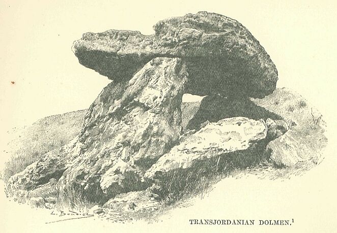
Drawn by Boudier, from a photograph.
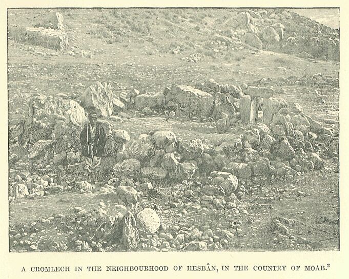
Drawn by Boudier, from a photograph.
Most of them were objects of worship: they were anointed with oil, and victims were slaughtered in their honour; the faithful even came at times to spend the night and sleep near them, in order to obtain in their dreams glimpses of the future.*
     * The menhir of Bethel was the identical one whereon Jacob
     rested his head on the night in which Jehovah appeared to
     him in a dream. In Phoenicia there was a legend which told
     how Usôos set up two stellæ to the elements of wind and fire,
     and how he offered the blood of the animals he had killed in
     the chase as a libation.
Men and beasts were supposed to be animated, during their lifetime, by a breath or soul which ran in their veins along with their blood, and served to move their limbs; the man, therefore, who drank blood or ate bleeding flesh assimilated thereby the soul which inhered in it. After death the fate of this soul was similar to that ascribed to the spirits of the departed in Egypt and Chaldæa. The inhabitants of the ancient world were always accustomed to regard the surviving element in man as something restless and unhappy—a weak and pitiable double, doomed to hopeless destruction if deprived of the succour of the living. They imagined it as taking up its abode near the body wrapped in a half-conscious lethargy; or else as dwelling with the other rephaim (departed spirits) in some dismal and gloomy kingdom, hidden in the bowels of the earth, like the region ruled by the Chaldæan Allât, its doors gaping wide to engulf new arrivals, but allowing none to escape who had once passed the threshold.*
     * The expression rephaim means "the feeble"; it was the
     epithet applied by the Hebrews to a part of the primitive
     races of Palestine.
There it wasted away, a prey to sullen melancholy, under the sway of inexorable deities, chief amongst whom, according to the Phoenician idea, was Mout (Death),* the grandson of El; there the slave became the equal of his former master, the rich man no longer possessed anything which could raise him above the poor, and dreaded monarchs were greeted on their entrance by the jeers of kings who had gone down into the night before them.
     *Among the Hebrews his name was Maweth, who feeds the
     departed like sheep, and himself feeds on them in hell. Some
     writers have sought to identify this or some analogous god
     with the lion represented on a stele of Piraeus which
     threatens to devour the body of a dead man.
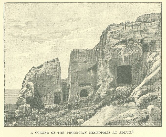
Drawn by Faucher-Gudin, from a photograph in Lortet.
The corpse, after it had been anointed with perfumes and enveloped in linen, and impregnated with substances which retarded its decomposition, was placed in some natural grotto or in a cave hollowed out of the solid rock: sometimes it was simply laid on the bare earth, sometimes in a sarcophagus or coffin, and on it, or around it, were piled amulets, jewels, objects of daily use, vessels filled with perfume, or household utensils, together with meat and drink. The entrance was then closed, and on the spot a cippus was erected—in popular estimation sometimes held to represent the soul—or a monument was set up on a scale proportionate to the importance of the family to which the dead man had belonged.* On certain days beasts ceremonially pure were sacrificed at the tomb, and libations poured out, which, carried into the next world by virtue of the prayers of those who offered them, and by the aid of the gods to whom the prayers were addressed, assuaged the hunger and thirst of the dead man.** The chapels and stellæ which marked the exterior of these "eternal"*** houses have disappeared in the course of the various wars by which Syria suffered so heavily: in almost all cases, therefore, we are ignorant as to the sites of the various cities of the dead in which the nobles and common people of the Canaanite and Amorite towns were laid to rest.****
     * The pillar or stele was used among both Hebrews and
     Phoenicians to mark the graves of distinguished persons.
     Among the Semites speaking Aramaic it was called nephesh,
     especially when it took the form of a pyramid; the word
     means "breath," "soul," and clearly shows the ideas
     associated with the object.

     ** An altar was sometimes placed in front of the sarcophagus
     to receive these offerings.

     *** This expression, which is identical with that used by
     the Egyptians of the same period, is found in one of the
     Phoenician inscriptions at Malta.

     **** The excavations carried out by M. Gautier in 1893-94,
     on the little island of Bahr-el-Kadis, at one time believed
     to have been the site of the town of Qodshu, have revealed
     the existence of a number of tombs in the enclosure which
     forms the central part of the tumulus: some of these may
     possibly date from the Amorite epoch, but they are very poor
     in remains, and contain no object which permits us to fix
     the date with accuracy.
In Phoenicia alone do we meet with burial-places which, after the vicissitudes and upheavals of thirty centuries, still retain something of their original arrangement. Sometimes the site chosen was on level ground: perpendicular shafts or stairways cut in the soil led down to low-roofed chambers, the number of which varied according to circumstances: they were often arranged in two stories, placed one above the other, fresh vaults being probably added as the old ones were filled up. They were usually rectangular in shape, with horizontal or slightly arched ceilings; niches cut in the walls received the dead body and the objects intended for its use in the next world, and were then closed with a slab of stone. Elsewhere some isolated hill or narrow gorge, with sides of fine homogeneous limestone, was selected.*
     * Such was the necropolis at Adlûn, the last rearrangement
     of which took place during the Græco-Roman period, but
     which externally bears so strong a resemblance to an
     Egyptian necropolis of the XVIIIth or XIXth dynasty, that we
     may, without violating the probabilities, trace its origin
     back to the time of the Pharaonic conquest.
In this case the doors were placed in rows on a sort of façade similar to that of the Egyptian rock-tomb, generally without any attempt at external ornament. The vaults were on the ground-level, but were not used as chapels for the celebration of festivals in honour of the dead: they were walled up after every funeral, and all access to them forbidden, until such time as they were again required for the purposes of burial. Except on these occasions of sad necessity, those whom "the mouth of the pit had devoured" dreaded the visits of the living, and resorted to every means afforded by their religion to protect themselves from them. Their inscriptions declare repeatedly that neither gold nor silver, nor any object which could excite the greed of robbers, was to be found within their graves; they threaten any one who should dare to deprive them of such articles of little value as belonged to them, or to turn them out of their chambers in order to make room for others, with all sorts of vengeance, divine and human. These imprecations have not, however, availed to save them from the desecration the danger of which they foresaw, and there are few of their tombs which were not occupied by a succession of tenants between the date of their first making and the close of the Roman supremacy. When the modern explorer chances to discover a vault which has escaped the spade of the treasure-seeker, it is hardly ever the case that the bodies whose remains are unearthed prove to be those of the original proprietors.

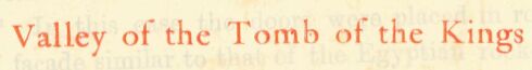
The gods and legends of Chaldæa had penetrated to the countries of Amauru and Canaan, together with the language of the conquerors and their system of writing: the stories of Adapa's struggles against the south-west wind, or of the incidents which forced Irishkigal, queen of the dead, to wed Nergal, were accustomed to be read at the courts of Syrian princes. Chaldæan theology, therefore, must have exercised influence on individual Syrians and on their belief; but although we are forced to allow the existence of such influence, we cannot define precisely the effects produced by it. Only on the coast and in the Phoenician cities do the local religions seem to have become formulated at a fairly early date, and crystallised under pressure of this influence into cosmogonie theories. The Baalim and Astartês reigned there as on the banks of the Jordan or Orontes, and in each town Baal was "the most high," master of heaven and eternity, creator of everything which exists, though the character of his creating acts was variously defined according to time and place. Some regarded him as the personification of Justice, Sydyk, who established the universe with the help of eight indefatigable Cabiri. Others held the whole world to be the work of a divine family, whose successive generations gave birth to the various elements. The storm-wind, Colpias, wedded to Chaos, had begotten two mortals, Ulom (Time) and Kadmôn (the First-Born), and these in their turn engendered Qên and Qênath, who dwelt in Phoenicia: then came a drought, and they lifted up their heads to the Sun, imploring him, as Lord of the Heavens (Baalsamîn), to put an end to their woes. At Tyre it was thought that Chaos existed at the beginning, but chaos of a dark and troubled nature, over which a Breath (rûakh) floated without affecting it; "and this Chaos had no ending, and it was thus for centuries and centuries.—Then the Breath became enamoured of its own principles, and brought about a change in itself, and this change was called Desire:—now Desire was the principle which created all things, and the Breath knew not its own creation.—The Breath and Chaos, therefore, became united, and Mot the Clay was born, and from this clay sprang all the seed of creation, and Mot was the father of all things; now Mot was like an egg in shape.—And the Sun, the Moon, the stars, the great planets, shone forth.* There were living beings devoid of intelligence, and from these living beings came intelligent beings, who were called Zophesamîn, or 'watchers of the heavens.'Now the thunder-claps in the war of separating elements awoke these intelligent beings as it were from a sleep, and then the males and the females began to stir themselves and to seek one another on the land and in the sea."
     * Mot, the clay formed by the corruption of earth and water,
     is probably a Phoenician form of a word which means water
     in the Semitic languages. Cf. the Egyptian theory, according
     to which the clay, heated by the sun, was supposed to have
     given birth to animated beings; this same clay modelled by
     Khnûmû into the form of an egg was supposed to have produced
     the heavens and the earth.
A scholar of the Roman epoch, Philo of Byblos, using as a basis some old documents hidden away in the sanctuaries, which had apparently been classified by Sanchoniathon, a priest long before his time, has handed these theories of the cosmogony down to us: after he has explained how the world was brought out of Chaos, he gives a brief summary of the dawn of civilization in Phoenicia and the legendary period in its history. No doubt he interprets the writings from which he compiled his work in accordance with the spirit of his time: he has none the less preserved their substance more or less faithfully. Beneath the veneer of abstraction with which the Greek tongue and mind have overlaid the fragment thus quoted, we discern that groundwork of barbaric ideas which is to be met with in most Oriental theologies, whether Egyptian or Babylonian. At first we have a black mysterious Chaos, stagnating in eternal waters, the primordial Nû or Apsû; then the slime which precipitates in this chaos and clots into the form of an egg, like the mud of the Nile under the hand? of Khnûmû; then the hatching forth of living organisms and indolent generations of barely conscious creatures, such as the Lakhmû, the Anshar, and the Illinu of Chaldæan speculation; finally the abrupt appearance of intelligent beings.
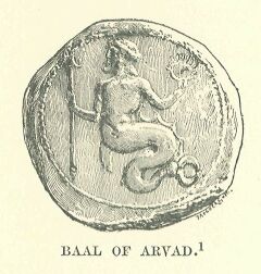
Drawn by Faucher-Gudin,
from the original in the
Cabinet des Médailles.
The Phoenicians, however, accustomed as they were to the Mediterranean, with its blind outbursts of fury, had formed an idea of Chaos which differed widely from that of most of the inland races, to whom it presented itself as something silent and motionless: they imagined it as swept by a mighty wind, which, gradually increasing to a roaring tempest, at length succeeded in stirring the chaos to its very depths, and in fertilizing its elements amidst the fury of the storm. No sooner had the earth been thus brought roughly into shape, than the whole family of the north winds swooped down upon it, and reduced it to civilized order. It was but natural that the traditions of a seafaring race should trace its descent from the winds.
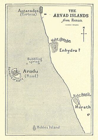
In Phoenicia the sea is everything: of land there is but just enough to furnish a site for a score of towns, with their surrounding belt of gardens. Mount Lebanon, with its impenetrable forests, isolated it almost entirely from Coele-Syria, and acted as the eastward boundary of the long narrow quadrangle hemmed in between the mountains and the rocky shore of the sea. At frequent intervals, spurs run out at right angles from the principal chain, forming steep headlands on the sea-front: these cut up the country, small to begin with, into five or six still smaller provinces, each one of which possessed from time immemorial its own independent cities, its own religion, and its own national history. To the north were the Zahi, a race half sailors, half husbandmen, rich, brave, and turbulent, ever ready to give battle to their neighbours, or rebel against an alien master, be he who he might. Arvad,* which was used by them as a sort of stronghold or sanctuary, was huddled together on an island some two miles from the coast: it was only about a thousand yards in circumference, and the houses, as though to make up for the limited space available for their foundations, rose to a height of five stories. An Astartê reigned there, as also a sea-Baal, half man, half fish, but not a trace of a temple or royal palace is now to be found.**
     * The name Arvad was identified in the Egyptian inscriptions
     by Birch, who, with Hincks, at first saw in the name a
     reference to the peoples of Ararat; Birch's identification,
     is now accepted by all Egyptologists. The name is written
     Aruada or Arada in the Tel el-Amarna tablets.

     ** The Arvad Astartê had been identified by the Egyptians
     with their goddess Bastît. The sea-Baal, who has been
     connected by some with Dagon of Askalon, is represented on
     the earliest Arvadian coins. He has a fish-like tail, the
     body and bearded head of a man, with an Assyrian headdress;
     on his breast we sometimes find a circular opening which
     seems to show the entrails.
The whole island was surrounded by a stone wall, built on the outermost ledges of the rocks, which were levelled to form its foundation. The courses of the masonry were irregular, laid without cement or mortar of any kind. This bold piece of engineering served the double purpose of sea-wall and rampart, and was thus fitted to withstand alike the onset of hostile fleets and the surges of the Mediterranean.*
     * The antiquity of the wall of Arvad, recognised by
     travellers of the last century, is now universally admitted
     by all archæologists.
There was no potable water on the island, and for drinking purposes the inhabitants were obliged to rely on the fall of rain, which they stored in cisterns—still in use among their descendants. In the event of prolonged drought they were obliged to send to the mainland opposite; in time of war they had recourse to a submarine spring, which bubbles up in mid-channel. Their divers let down a leaden bell, to the top of which was fitted a leathern pipe, and applied it to the orifice of the spring; the fresh water coming up through the sand was collected in this bell, and rising in the pipe, reached the surface uncontaminated by salt water.*
     * Renan tells us that "M. Gaillardot, when crossing from the
     island to the mainland, noticed a spring of sweet water
     bubbling up from the bottom of the sea.... Thomson and
     Walpole noticed the same spring or similar springs a little
     to the north of Tortosa."
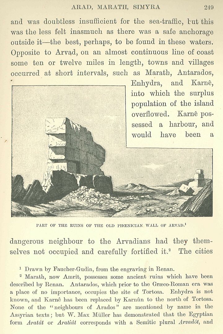
The harbour opened to the east, facing the mainland: it was divided into two basins by a stone jetty, and was doubtless insufficient for the sea-traffic, but this was the less felt inasmuch as there was a safe anchorage outside it—the best, perhaps, to be found in these waters. Opposite to Arvad, on an almost continuous line of coast some ten or twelve miles in length, towns and villages occurred at short intervals, such as Marath, Antarados, Enhydra, and Karnê, into which the surplus population of the island overflowed. Karnê possessed a harbour, and would have been a dangerous neighbour to the Arvadians had they themselves not occupied and carefully fortified it.*
     * Marath, now Amrît, possesses some ancient ruins which have
     been described by Renan. Antarados, which prior to the
     Græco-Roman era was a place of no importance, occupies the
     site of Tortosa. Enhydra is not known, and Karnê has been
     replaced by Karnûn to the north of Tortosa. None of the
     "neighbours of Arados" are mentioned by name in the Assyrian
     texts; but W. Max Müller has demonstrated that the Egyptian
     form Aratût or Aratiût corresponds with a Semitic plural
     Arvadôt, and consequently refers not only to Arad itself,
     but also to the fortified cities and towns which formed its
     continental suburbs.
The cities of the dead lay close together in the background, on the slope of the nearest chain of hills; still further back lay a plain celebrated for its fertility and the luxuriance of its verdure: Lebanon, with its wooded peaks, was shut in on the north and south, but on the east the mountain sloped downwards almost to the sea-level, furnishing a pass through which ran the road which joined the great military highway not far from Qodshu. The influence of Arvad penetrated by means of this pass into the valley of the Orontes, and is believed to have gradually extended as far as Hamath itself—in other words, over the whole of Zahi. For the most part, however, its rule was confined to the coast between G-abala and the Nahr el-Kebîr; Simyra at one time acknowledged its suzerainty, at another became a self-supporting and independent state, strong enough to compel the respect of its neighbours.* Beyond the Orontes, the coast curves abruptly inward towards the west, and a group of wind-swept hills ending in a promontory called Phaniel,** the reputed scene of a divine manifestation, marked the extreme limit of Arabian influence to the north, if, indeed, it ever reached so far.
     * Simyra is the modern Surnrah, near the Nahr el-Kebîr.

     ** The name has only come down to us under its Greek form,
     but its original form, Phaniel or Penûel, is easily arrived
     at from the analogous name used in Canaan to indicate
     localities where there had been a theophany. Renan questions
     whether Phaniel ought not to be taken in the same sense as
     the Pnê-Baal of the Carthaginian inscriptions, and applied
     to a goddess to whom the promontory had been dedicated; he
     also suggests that the modern name Cap Madonne may be a
     kind of echo of the title Rabbath borne by this goddess
     from the earliest times.
Half a dozen obscure cities flourished here, Arka,* Siani,** Mahallat, Kaiz, Maîza, and Botrys,*** some of them on the seaboard, others inland on the bend of some minor stream. Botrys,**** the last of the six, barred the roads which cross the Phaniel headland, and commanded the entrance to the holy ground where Byblos and Berytus celebrated each year the amorous mysteries of Adonis.
     * Arka is perhaps referred to in the tablets of Tel el-
     Amarna under the form Irkata or Irkat; it also appears in
     the Bible (Gen. x. 17) and in the Assyrian texts. It is the
     Cassarea of classical geographers, which has now resumed its
     old Phoenician name of Tell-Arka.

     ** Sianu or Siani is mentioned in the Assyrian texts and in
     the Bible; Strabo knew it under the name of Sinna, and a
     village near Arka was called Sin or Syn as late as the XVth
     century.

     *** According to the Assyrian inscriptions, these were the
     names of the three towns which formed the Tripolis of
     Græco-Roman times.

     **** Botrys is the hellenized form of the name Bozruna or
     Bozrun, which appears on the tablets of Tel el-Amarna; the
     modern name, Butrun or Batrun, preserves the final letter
     which the Greeks had dropped.
Gublu, or—as the Greeks named it—Byblos,* prided itself on being the most ancient city in the world. The god El had founded it at the dawning of time, on the flank of a hill which is visible from some distance out at sea. A small bay, now filled up, made it an important shipping centre. The temple stood on the top of the hill, a few fragments of its walls still serving to mark the site; it was, perhaps, identical with that of which we find the plan engraved on certain imperial coins.**
     * Gublu or Gubli is the pronunciation indicated for this
     name in the Tel el-Amarna tablets; the Egyptians transcribed
     it Kupuna or Kupna by substituting n for l. The
     Greek name Byblos was obtained from Gublu by substituting a
     b for the g.

     ** Renan carried out excavations in the hill of Kassubah
     which brought to light some remains of a Græco-Roman temple:
     he puts forward, subject to correction, the hypothesis which
     I have adopted above.
Two flights of steps led up to it from the lower quarters of the town, one of which gave access to a chapel in the Greek style, surmounted by a triangular pediment, and dating, at the earliest, from the time of the Seleucides; the other terminated in a long colonnade, belonging to the same period, added as a new façade to an earlier building, apparently in order to bring it abreast of more modern requirements.
The sanctuary which stands hidden behind this incongruous veneer is, as represented on the coins, in a very archaic style, and is by no means wanting in originality or dignity. It consists of a vast rectangular court surrounded by cloisters. At the point where lines drawn from the centres of the two doors seem to cross one another stands a conical stone mounted on a cube of masonry, which is the beth-el animated by the spirit of the god: an open-work balustrade surrounds and protects it from the touch of the profane. The building was perhaps not earlier than the Assyrian or Persian era, but in its general plan it evidently reproduced the arrangements of some former edifice.*
     * The author of the De Deâ Syrâ classed the temple of
     Byblos among the Phoenician temples of the old order, which
     were almost as ancient as the temples of Egypt, and it is
     probable that from the Egyptian epoch onwards the plan of
     this temple must have been that shown on the coins; the
     cloister arcades ought, however, to be represented by
     pillars or by columns supporting architraves, and the fact
     of their presence leads me to the conclusion that the temple
     did not exist in the form known to us at a date earlier than
     the last Assyrian period.
At an early time El was spoken of as the first king of G-ablu in the same manner as each one of his Egyptian fellow-gods had been in their several nomes, and the story of his exploits formed the inevitable prelude to the beginning of human history. Grandson of Eliûn who had brought Chaos into order, son of Heaven and Earth, he dispossessed, vanquished, and mutilated his father, and conquered the most distant regions one after another—the countries beyond the Euphrates, Libya, Asia Minor and Greece: one year, when the plague was ravaging his empire, he burnt his own son on the altar as an expiatory victim, and from that time forward the priests took advantage of his example to demand the sacrifice of children in moments of public danger or calamity.
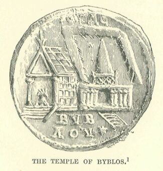
Drawn by Faucher-Gudin,
from the original in the
Cabinet des Médailles.
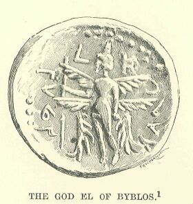
Drawn by Faucher-Gudin,
from the original in the
Cabinet des Médailles.
He was represented as a man with two faces, whose eyes opened and shut in an eternal alternation of vigilance and repose: six wings grew from his shoulders, and spread fan-like around him. He was the incarnation of time, which destroys all things in its rapid flight; and of the summer sun, cruel and fateful, which eats up the green grass and parches the fields. An Astartê reigned with him over Byblos—Baalat-Gublu, his own sister; like him, the child of Earth and Heaven. In one of her aspects she was identified with the moon, the personification of coldness and chastity, and in her statues or on her sacred pillars she was represented with the crescent or cow-horns of the Egyptian Hâthor; but in her other aspect she appeared as the amorous and wanton goddess in whom the Greeks recognised the popular concept of Aphroditê. Tradition tells us how, one spring morning, she caught sight of and desired the youthful god known by the title of Adoni, or "My Lord." We scarce know what to make of the origin of Adonis, and of the legends which treat him as a hero—the representation of him as the incestuous offspring of a certain King Kinyras and his own daughter Myrrha is a comparatively recent element grafted on the original myth; at any rate, the happiness of two lovers had lasted but a few short weeks when a sudden end was put to it by the tusks of a monstrous wild boar. Baalat-Gublu wept over her lover's body and buried it; then her grief triumphed over death, and Adonis, ransomed by her tears, rose from the tomb, his love no whit less passionate than it had been before the catastrophe. This is nothing else than the Chaldæan legend of Ishtar and Dûmûzi presented in a form more fully symbolical of the yearly marriage of Earth and Heaven. Like the Lady of Byblos at her master's approach, Earth is thrilled by the first breath of spring, and abandons herself without shame to the caresses of Heaven: she welcomes him to her arms, is fructified by him, and pours forth the abundance of her flowers and fruits. Them comes summer and kills the spring: Earth is burnt up and withers, she strips herself of her ornaments, and her fruitfulness departs till the gloom and icy numbness of winter have passed away. Each year the cycle of the seasons brings back with it the same joy, the same despair, into the life of the world; each year Baalat falls in love with her Adonis and loses him, only to bring him back to life and lose him again in the coming year.
The whole neighbourhood of Byblos, and that part of Mount Lebanon in which it lies, were steeped in memories of this legend from the very earliest times. We know the precise spot where the goddess first caught sight of her lover, where she unveiled herself before him, and where at the last she buried his mutilated body, and chanted her lament for the dead. A river which flows southward not far off was called the Adonis, and the valley watered by it was supposed to have been the scene of this tragic idyll. The Adonis rises near Aphaka,* at the base of a narrow amphitheatre, issuing from the entrance of an irregular grotto, the natural shape of which had, at some remote period, been altered by the hand of man; in three cascades it bounds into a sort of circular basin, where it gathers to itself the waters of the neighbouring springs, then it dashes onwards under the single arch of a Roman bridge, and descends in a series of waterfalls to the level of the valley below.
     * Aphaka means "spring" in Syriac. The site of the temple and
     town of Aphaka, where a temple of Aphroditê and Adonis still
     stood in the time of the Emperor Julian, had long been
     identified either with Fakra, or with El-Yamuni. Seetzen was
     the first to place it at El-Afka, and his proposed
     identification has been amply confirmed by the researches of
     Penan.
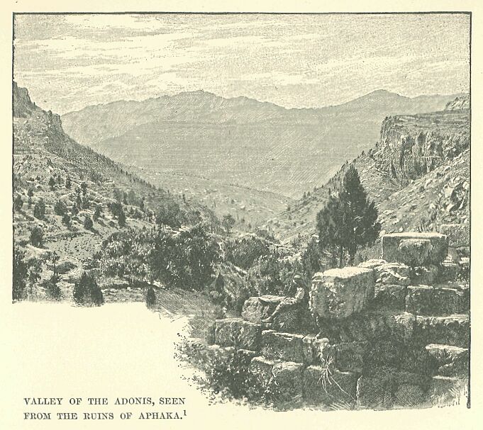
Drawn by Boudier, from a photograph.
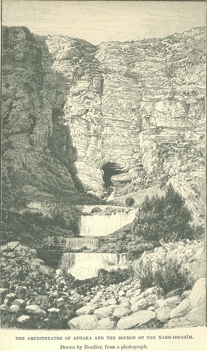
Drawn by Boudier, from a photograph.
The temple rises opposite the source of the stream on an artificial mound, a meteorite fallen from heaven having attracted the attention of the faithful to the spot. The mountain falls abruptly away, its summit presenting a red and bare appearance, owing to the alternate action of summer sun and winter frost. As the slopes approach the valley they become clothed with a garb of wild vegetation, which bursts forth from every fissure, and finds a foothold on every projecting rock: the base of the mountain is hidden in a tangled mass of glowing green, which the moist yet sunny Spring calls forth in abundance whenever the slopes are not too steep to retain a shallow layer of nourishing mould. It would be hard to find, even among the most picturesque spots of Europe, a landscape in which wildness and beauty are more happily combined, or where the mildness of the air and sparkling coolness of the streams offer a more perfect setting for the ceremonies attending the worship of Astartê.*
     * The temple had been rebuilt during the Roman period, as
     were nearly all the temples of this region, upon the site of
     a more ancient structure; this was probably the edifice
     which the author of De Deâ Syrâ considered to be the
     temple of Venus, built by Kinyras within a day's journey of
     Byblos in the Lebanon.
In the basin of the river and of the torrents by which it is fed, there appears a succession of charming and romantic scenes—gaping chasms with precipitous ochre-coloured walls; narrow fields laid out in terraces on the slopes, or stretching in emerald strips along the ruddy river-banks; orchards thick with almond and walnut trees; sacred grottoes, into which the priestesses, seated at the corner of the roads, endeavour to draw the pilgrims as they proceed on their way to make their prayers to the goddess;* sanctuaries and mausolea of Adonis at Yanukh, on the table-land of Mashnaka, and on the heights of Ghineh. According to the common belief, the actual tomb of Adonis was to be found at Byblos itself,** where the people were accustomed to assemble twice a year to keep his festivals, which lasted for several days together.
     * Renan points out at Byblos the existence of one of these
     caverns which gave shelter to the kedeshoth. Many of the
     caves met with in the valley of the Nahr-Ibrahîm have
     doubtless served for the same purpose, although their walls
     contain no marks of the cult.

     ** Melito placed it, however, near Aphaka, and, indeed,
     there must have been as many different traditions on the
     subject as there were celebrated sanctuaries.
At the summer solstice, the season when the wild boar had ripped open the divine hunter, and the summer had already done damage to the spring, the priests were accustomed to prepare a painted wooden image of a corpse made ready for burial, which they hid in what were called the gardens of Adonis—terra-cotta pots filled with earth in which wheat and barley, lettuce and fennel, were sown. These were set out at the door of each house, or in the courts of the temple, where the sprouting plants had to endure the scorching effect of the sun, and soon withered away. For several days troops of women and young girls, with their heads dishevelled or shorn, their garments in rags, their faces torn with their nails, their breasts and arms scarified with knives, went about over hill and dale in search of their idol, giving utterance to cries of despair, and to endless appeals: "Ah, Lord! Ah, Lord! what is become of thy beauty." Once having found the image, they brought it to the feet of the goddess, washed it while displaying its wound, anointed it with sweet-smelling unguents, wrapped it in a linen and woollen shroud, placed it on a catafalque, and, after expressing around the bier their feelings of desolation, according to the rites observed at fanerais, placed it solemnly in the tomb.*
     * Theocritus has described in his fifth Idyll the laying out
     and burial of Adonis as it was practised at Alexandria in
     Egypt in the IIIrd century before our era.
The close and dreary summer passes away. With the first days of September the autumnal rains begin to fall upon the hills, and washing away the ochreous earth lying upon the slopes, descend in muddy torrents into the hollows of the valleys. The Adonis river begins to swell with the ruddy waters, which, on reaching the sea, do not readily blend with it. The wind from the offing drives the river water back upon the coast, and forces it to cling for a long time to the shore, where it forms a kind of crimson fringe.* This was the blood of the hero, and the sight of this precious stream stirred up anew the devotion of the people, who donned once more their weeds of mourning until the priests were able to announce to them that, by virtue of their supplications, Adonis was brought back from the shades into new life. Shouts of joy immediately broke forth, and the people who had lately sympathized with the mourning goddess in her tears and cries of sorrow, now joined with her in expressions of mad and amorous delight. Wives and virgins—all the women who had refused during the week of mourning to make a sacrifice of their hair—were obliged to atone for this fault by putting themselves at the disposal of the strangers whom the festival had brought together, the reward of their service becoming the property of the sacred treasury.**
     * The same phenomenon occurs in spring. Maundrell saw it on
     March 17, and Renan in the first days of February.

     ** A similar usage was found in later times in the countries
     colonised by or subjected to the influence of the
     Phoenicians, especially in Cyprus.
Berytus shared with Byblos the glory of having had El for its founder.* The road which connects these two cities makes a lengthy detour in its course along the coast, having to cross numberless ravines and rocky summits: before reaching Palai-Byblos, it passes over a headland by a series of steps cut into the rock, forming a kind of "ladder" similar to that which is encountered lower down, between Acre and the plains of Tyre.
     * The name Berytus was found by Hincks in the Egyptian texts
     under the form. Bîrutu, Beîrutu; it occurs frequently in the
     Tel el-Amarna tablets.
The river Lykos runs like a kind of natural fosse along the base of this steep headland. It forms at the present time a torrent, fed by the melting snows of Mount Sannin, and is entirely unnavigable. It was better circumstanced formerly in this respect, and even in the early years of the Boman conquest, sailors from Arvad (Arados) were accustomed to sail up it as far as one of the passes of the lower Lebanon, leading into Cole-Syria. Berytus was installed at the base of a great headland which stands out boldly into the sea, and forms the most striking promontory to be met with in these regions from Carmel to the vicinity of Arvad. The port is nothing but an open creek with a petty roadstead, but it has the advantage of a good supply of fresh water, which pours down from the numerous springs to which it is indebted for its name.* According to ancient legends, it was given by El to one of his offspring called Poseidon by the Greeks.
     * The name Beyrut has been often derived from a Phconician
     word signifying cypress, and which may have been applied
     to the pine tree. The Phoenicians themselves derived it from
     Bîr, "wells."
Adonis desired to take possession of it, but was frustrated in the attempt, and the maritime Baal secured the permanence of his rule by marrying one of his sisters—the Baalat-Beyrut who is represented as a nymph on Græco-Roman coins.* The rule of the city extended as far as the banks of the Tamur, and an old legend narrates that its patron fought in ancient times with the deity of that river, hurling stones at him to prevent his becoming master of the land to the north. The bar formed of shingle and the dunes which contract the entrance were regarded as evidences of this conflict.**
     * The poet Nonnus has preserved a highly embellished account
     of this rivalry, where Adonis is called Dionysos.

     ** The original name appears to have been Tamur, Tamyr, from
     a word signifying "palm" in the Phoenician language. The
     myth of the conflict between Poseidon and the god of the
     river, a Baal-Demarous, has been explained by Renan, who
     accepts the identification of the river-deity with Baal-
     Thamar, already mentioned by Movers.
Beyond the southern bank of the river, Sidon sits enthroned as "the firstborn of Canaan." In spite of this ambitious title it was at first nothing but a poor fishing village founded by Bel, the Agenor of the Greeks, on the southern slope of a spit of land which juts out obliquely towards the south-west.* It grew from year to year, spreading out over the plain, and became at length one of the most prosperous of the chief cities of the country—a "mother" in Phoenicia.**
     * Sidon is called "the firstborn of Canaan" in Genesis: the
     name means a fishing-place, as the classical authors already
     knew—"nam piscem Phonices sidôn appellant."

     ** In the coins of classic times it is called "Sidon, the
     mother—Om—of Kambe, Hippo, Citium, and Tyre."
The port, once so celebrated, is shut in by three chains of half-sunken reefs, which, running out from the northern end of the peninsula, continue parallel to the coast for some hundreds of yards: narrow passages in these reefs afford access to the harbour; one small island, which is always above water, occupies the centre of this natural dyke of rocks, and furnishes a site for a maritime quarter opposite to the continental city.* The necropolis on the mainland extends to the east and north, and consists of an irregular series of excavations made in a low line of limestone cliffs which must have been lashed by the waves of the Mediterranean long prior to the beginning of history. These tombs are crowded closely together, ramifying into an inextricable maze, and are separated from each other by such thin walls that one expects every moment to see them give way, and bury the visitors in the ruin. Many date back to a very early period, while all of them have been re-worked and re-appropriated over and over again. The latest occupiers were contemporaries of the Macedonian kings or the Roman Cæsars. Space was limited and costly in this region of the dead: the Sidonians made the best use they could of the tombs, burying in them again and again, as the Egyptians were accustomed to do in their cemeteries at Thebes and Memphis. The surrounding plain is watered by the "pleasant Bostrênos," and is covered with gardens which are reckoned to be the most beautiful in all Syria—at least after those of Damascus: their praises were sung even in ancient days, and they had then earned for the city the epithet of "the flowery Sidon."**
     * The only description of the port which we possess is that
     in the romance of Olitophon and Leucippus by Achilles
     Tatius.

     ** The Bostrênos, which is perhaps to be recognised under
     the form Borinos in the Periplus of Scylax, is the modern
     Nahr el-Awaly.
Here, also, an Astartê ruled over the destinies of the people, but a chaste and immaculate Astartê, a self-restrained and warlike virgin, sometimes identified with the moon, sometimes with the pale and frigid morning star.* In addition to this goddess, the inhabitants worshipped a Baal-Sidon, and other divinities of milder character—an Astartê Shem-Baal, wife of the supreme Baal, and Eshmun, a god of medicine—each of whom had his own particular temple either in the town itself or in some neighbouring village in the mountain. Baal delighted in travel, and was accustomed to be drawn in a chariot through the valleys of Phoenicia in order to receive the prayers and offerings of his devotees. The immodest Astartê, excluded, it would seem, from the official religion, had her claims acknowledged in the cult offered to her by the people, but she became the subject of no poetic or dolorous legend like her namesake at Byblos, and there was no attempt to disguise her innately coarse character by throwing over it a garb of sentiment. She possessed in the suburbs her chapels and grottoes, hollowed out in the hillsides, where she was served by the usual crowd of Ephébæ and sacred courtesans. Some half-dozen towns or fortified villages, such as Bitzîti,** the Lesser Sidon, and Sarepta, were scattered along the shore, or on the lowest slopes of the Lebanon.
     * Astartê is represented in the Bible as the goddess of the
     Sidonians, and she is in fact the object of the invocations
     addressed to the mistress Deity in the Sidonian
     inscriptions, the patroness of the town. Kings and queens
     were her priests and priestesses respectively.

     ** Bitzîti is not mentioned except in the Assyrian texts,
     and has been identified with the modern region Ait ez-Zeîtûn
     to the south-east of Sidon. It is very probably the Elaia of
     Philo of Byblos, the Biais of Dionysios Periegetes, which
     Renan is inclined to identify with Heldua, Khan-Khaldi, by
     substituting Eldis as a correction.
Sidonian territory reached its limit at the Cape of Sarepta, where the high-lands again meet the sea at the boundary of one of those basins into which Phoenicia is divided. Passing beyond this cape, we come first upon a Tyrian outpost, the Town of Birds;* then upon the village of Nazana** with its river of the same name; beyond this upon a plain hemmed in by low hills, cultivated to their summits; then on tombs and gardens in the suburbs of Autu;*** and, further still, to a fleet of boats moored at a short distance from the shore, where a group of reefs and islands furnishes at one and the same time a site for the houses and temples of Tyre, and a protection from its foes.
     * The Phoenician name of Ornithônpolis is unknown to us: the
     town is often mentioned by the geographers of classic times,
     but with certain differences, some placing it to the north
     and others to the south of Sarepta. It was near to the site
     of Adlun, the Adnonum of the Latin itineraries, if it was
     not actually the same place.

     ** Nazana was both the name of the place and the river, as
     Kasimîyeh and Khan Kasimîyeh, near the same locality, are
     to-day.

     *** Autu was identified by Brugsch with Avatha, which is
     probably El-Awwâtîn, on the hill facing Tyre. Max Müller,
     who reads the word as Authu, Ozu, prefers the Uru or Ushu of
     the Assyrian texts.
It was already an ancient town at the beginning of the Egyptian conquest. As in other places of ancient date, the inhabitants rejoiced in stories of the origin of things in which the city figured as the most venerable in the world. After the period of the creating gods, there followed immediately, according to the current legends, two or three generations of minor deities—heroes of light and flame—who had learned how to subdue fire and turn it to their needs; then a race of giants, associated with the giant peaks of Kasios, Lebanon, Hermon, and Brathy;* after which were born two male children—twins: Samem-rum, the lord of the supernal heaven, and Usôos, the hunter. Human beings at this time lived a savage life, wandering through the woods, and given up to shameful vices.
     * The identification of the peak of Brathy is uncertain. The
     name has been associated with Tabor: since it exactly
     recalls the name of the cypress and of Berytus, it would be
     more prudent, perhaps, to look for the name in that of one
     of the peaks of the Lebanon near the latter town.
Samemrum took up his abode among them in that region which became in later times the Tyrian coast, and showed them how to build huts, papyrus, or other reeds: Usôos in the mean time pursued the avocation of a hunter of wild beasts, living upon their flesh and clothing himself with their skins. A conflict at length broke out between the two brothers, the inevitable result of rivalry between the ever-wandering hunter and the husbandman attached to the soil.
Usôos succeeded in holding his own till the day when fire and wind took the part of his enemy against him.* The trees, shaken and made to rub against each other by the tempest, broke into flame from the friction, and the forest was set on fire. Usôos, seizing a leafy branch, despoiled it of its foliage, and placing it in the water let it drift out to sea, bearing him, the first of his race, with it.
     * The text simply states the material facts, the tempest and
     the fire: the general movement of the narrative seems to
     prove that the intervention of these elements is an episode
     in the quarrel between the two brothers—that in which
     Usôos is forced to fly from the region civilized by
     Samemrum.
Landing on one of the islands, he set up two menhirs, dedicating them to fire and wind that he might thenceforward gain their favour. He poured out at their base the blood of animals he had slaughtered, and after his death, his companions continued to perform the rites which he had inaugurated.
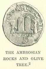
Drawn by Faucher-Gudin,
from the original in the
Cabinet des Médailles.
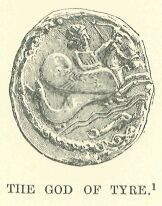
Drawn by Faucher-Gudin,
from the original in the
Cabinet des Médailles.
The town which he had begun to build on the sea-girt isle was called Tyre, the "Rock," and the two rough stones which he had set up remained for a long time as a sort of talisman, bringing good luck to its inhabitants. It was asserted of old that the island had not always been fixed, but that it rose and fell, with the waves like a raft. Two peaks looked down upon it—the "Ambrosian Rocks"—between which grew the olive tree of Astartê, sheltered by a curtain of flame from external danger. An eagle perched thereon watched over a viper coiled round the trunk: the whole island would cease to float as soon as a mortal should succeed in sacrificing the bird in honour of the gods. Usôos, the Herakles, destroyer of monsters, taught the people of the coast how to build boats, and how to manage them; he then made for the island and disembarked: the bird offered himself spontaneously to his knife, and as soon as its blood had moistened the earth, Tyre rooted itself fixedly opposite the mainland. Coins of the Roman period represent the chief elements in this legend; sometimes the eagle and olive tree, sometimes the olive tree and the stelo, and sometimes the two stelæ only. From this time forward the gods never ceased to reside on the holy island; Astartê herself was born there, and one of the temples there showed to the admiration of the faithful a fallen star—an aerolite which she had brought back from one of her journeys.
Baal was called the Melkarth. king of the city, and the Greeks after» wards identified him with their Herakles. His worship was of a severe and exacting character: a fire burned perpetually in his sanctuary; his priests, like those of the Egyptians, had their heads shaved; they wore garments of spotless white linen, held pork in abomination, and refused permission to married women to approach the altars.*
     * The worship of Melkarth at Gados (Cadiz) and the functions
     of his priests are described by Silius Italicus: as Gades
     was a Tyrian colony, it has been naturally assumed that the
     main features of the religion of Tyre were reproduced there,
     and Silius's account of the Melkarth of Gades thus applies
     to his namesake of the mother city.
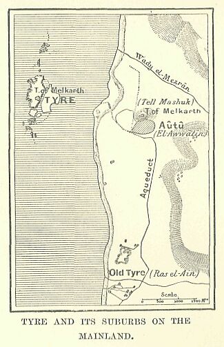
Festivals, similar to those of Adonis at Byblos, were held in his honour twice a year: in the summer, when the sun burnt up the earth with his glowing heat, he offered himself as an expiatory victim to the solar orb, giving himself to the flames in order to obtain some mitigation of the severity of the sky;* once the winter had brought with it a refreshing coolness, he came back to life again, and his return was celebrated with great joy. His temple stood in a prominent place on the largest of the islands furthest away from the mainland. It served to remind the people of the remoteness of their origin, for the priests relegated its foundation almost to the period of the arrival of the Phoenicians on the shores of the Mediterranean. The town had no supply of fresh water, and there was no submarine spring like that of Arvad to provide a resource in time of necessity; the inhabitants had, therefore, to resort to springs which were fortunately to be found everywhere on the hillsides of the mainland. The waters of the well of Eas el-Aîn had been led down to the shore and dammed up there, so that boats could procure a ready supply from this source in time of peace: in time of war the inhabitants of Tyre had to trust to the cisterns in which they had collected the rains that fell at certain seasons.**
     * The festival commemorating his death by fire was
     celebrated at Tyre, where his tomb was shown, and in the
     greater number of the Tyrian colonies.

     ** Abisharri (Abimilki), King of Tyre, confesses to the
     Pharaoh Amenôthes III. that in case of a siege his town
     would neither have water nor wood. Aqueducts and conduits of
     water are spoken of by Menander as existing in the time of
     Shalmaneser; all modern historians agree in attributing
     their construction to a very remote antiquity.
The strait separating the island from the mainland was some six or seven hundred yards in breadth,* less than that of the Nile at several points of its course through Middle Egypt, but it was as effective as a broader channel to stop the movement of an army: a fleet alone would have a chance of taking the city by surprise, or of capturing it after a lengthened siege.
     * According to the writers who were contemporary with
     Alexander, the strait was 4 stadia wide (nearly 1/2 mile),
     or 500 paces (about 3/8 mile), at the period when the
     Macedonians undertook the siege of the town; the author
     followed by Pliny says 700 paces, possibly over—mile wide.
     From the observations of Poulain de Bossay, Renan thinks the
     space between the island and the mainland might be nearly a
     mile in width, but we should perhaps do well to reduce this
     higher figure and adopt one agreeing better with the
     statements of Diodorus and Quintus Curtius.
Like the coast region opposite Arvad, the shore which faced Tyre, lying between the mouth of the Litany and ras el-Aîn, was an actual suburb of the city itself—with its gardens, its cultivated fields, its cemeteries, its villas, and its fortifications. Here the inhabitants of the island were accustomed to bury their dead, and hither they repaired for refreshment during the heat of the summer. To the north the little town of Mahalliba, on the southern bank of the Litâny, and almost hidden from view by a turn in the hills, commanded the approaches to the Bekaa, and the high-road to Coele-Syria.* To the south, at Ras el-Aîn, Old Tyre (Palastyrus) looked down upon the route leading into Galilee by way of the mountains.**
     * Mahalliba is the present Khurbet-Mahallib.

     ** Palrotyrus has often been considered as a Tyre on the
     mainland of greater antiquity than the town of the same name
     on the island; it is now generally admitted that it was
     merely an outpost, which is conjecturally placed by most
     scholars in the neighbourhood of Ras el-Aîn.
Eastwards Autu commanded the landing-places on the shore, and served to protect the reservoirs; it lay under the shadow of a rock, on which was built, facing the insular temple of Melkarth, protector of mariners, a sanctuary of almost equal antiquity dedicated to his namesake of the mainland.* The latter divinity was probably the representative of the legendary Samemrum, who had built his village on the coast, while Usôos had founded his on the ocean. He was the Baalsamîm of starry tunic, lord of heaven and king of the sun.
     * If the name has been preserved, as I believe it to be, in
     that of El-Awwâtîn, the town must be that whose ruins we
     find at the foot of Tell-Mashûk, and which are often
     mistaken for those of Palastyrus. The temple on the summit
     of the Tell was probably that of Heracles Astrochitôn
     mentioned by Nonnus.
As was customary, a popular Astartê was associated with these deities of high degree, and tradition asserted that Melkarth purchased her favour by the gift of the first robe of Tyrian purple which was ever dyed. Priestesses of the goddess had dwellings in all parts of the plain, and in several places the caves are still pointed out where they entertained the devotees of the goddess. Behind Autu the ground rises abruptly, and along the face of the escarpment, half hidden by trees and brushwood, are the remains of the most important of the Tyrian burying-places, consisting of half-filled-up pits, isolated caves, and dark galleries, where whole families lie together in their last sleep. In some spots the chalky mass has been literally honeycombed by the quarrying gravedigger, and regular lines of chambers follow one another in the direction of the strata, after the fashion of the rock-cut tombs of Upper Egypt. They present a bare and dismal appearance both within and without. The entrances are narrow and arched, the ceilings low, the walls bare and colourless, unrelieved by moulding, picture, or inscription. At one place only, near the modern village of Hanaweh, a few groups of figures and coarsely cut stelae are to be found, indicating, it would seem, the burying-place of some chief of very early times.
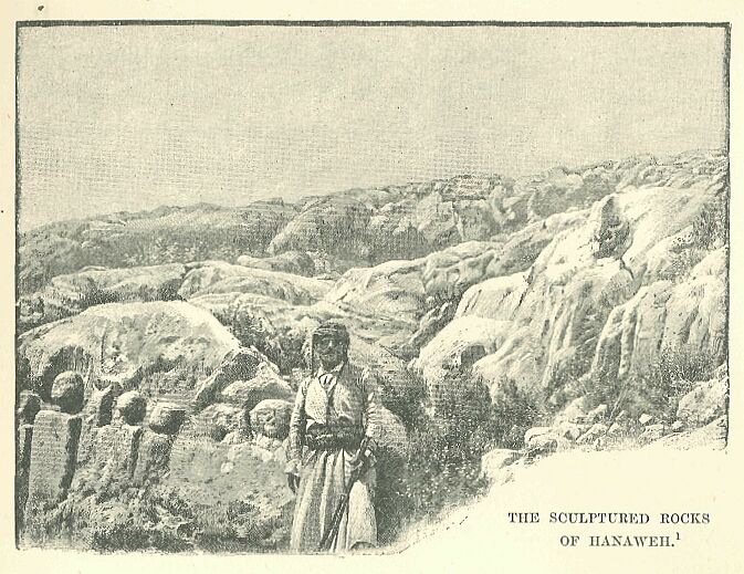
Drawn by Boudier, from a photograph by Lortet.
These figures run in parallel lines along the rocky sides of a wild ravine. They vary from 2 feet 6 inches to 3 feet in height, the bodies being represented by rectangular pilasters, sometimes merely rough-hewn, at others grooved with curved lines to suggest the folds of the Asiatic garments; the head is carved full face, though the eyes are given in profile, and the summary treatment of the modelling gives evidence of a certain skill. Whether they are to be regarded as the product of a primitive Amorite art or of a school of Phoenician craftsmen, we are unable to determine. In the time of their prosperity the Tyrians certainly pushed their frontier as far as this region. The wind-swept but fertile country lying among the ramifications of the lowest spurs of the Lebanon bears to this day innumerable traces of their indefatigable industry—remains of dwellings, conduits and watercourses, cisterns, pits, millstones and vintage-troughs, are scattered over the fields, interspersed with oil and wine presses. The Phoenicians took naturally to agriculture, and carried it to such a high state of perfection as to make it an actual science, to which the neighbouring peoples of the Mediterranean were glad to accommodate their modes of culture in later times.*
     * Their taste for agriculture, and the comparative
     perfection of their modes of culture, are proved by the
     greatness of the remains still to be observed: "The
     Phoenicians constructed a winepress, a trough, to last for
     ever." Their colonists at Carthage carried with them the same
     clever methods, and the Romans borrowed many excellent
     things in the way of agriculture from Carthaginian books,
     especially from those of Mago.
Among no other people was the art of irrigation so successfully practised, and from such a narrow strip of territory as belonged to them no other cultivators could have gathered such abundant harvests of wheat and barley, and such supplies of grapes, olives, and other fruits. From Arvad to Tyre, and even beyond it, the littoral region and the central parts of the valleys presented a long ribbon of verdure of varying breadth, where fields of corn were blended with gardens and orchards and shady woods. The whole region was independent and self-supporting, the inhabitants having no need to address themselves to their neighbours in the interior, or to send their children to seek their fortune in distant lands. To insure prosperity, nothing was needed but a slight exercise of labour and freedom from the devastating influence of war.
The position of the country was such as to secure it from attack, and from the conflicts which laid waste the rest of Syria. Along almost the entire eastern border of the country the Lebanon was a great wall of defence running parallel to the coast, strengthened at each extremity by the additional protection of the rivers Nahr el-Kebîr and Litany. Its slopes were further defended by the forest, which, with its lofty trees and brushwood, added yet another barrier to that afforded by rocks and snow. Hunters' or shepherds' paths led here and there in tortuous courses from one side of the mountain to the other. Near the middle of the country two roads, practicable in all seasons, secured communications between the littoral and the plain of the interior. They branched off on either side from the central road in the neighbourhood of Tabakhi, south of Qodshu, and served the needs of the wooded province of Magara.* This region was inhabited by pillaging tribes, which the Egyptians called at one time Lamnana, the Libanites,** at others Shausu, using for them the same appellation as that which they bestowed upon the Bedouin of the desert.
     * Magara is mentioned in the Anastasi Papyrus, No. 1, and
     Chabas has identified it with the plain of Macra, which
     Strabo places in Syria, in the neighbourhood of Eloutheros.

     ** The name Lamnana is given in a picture of the campaigns
     of Seti I.
The roads through this province ran under the dense shade afforded by oaks, cedars, and cypresses, in an obscurity favourable to the habits of the wolves and hyamas which infested it, and even of those thick-maned lions known to Asia at the time; and then proceeding in its course, crossed the ridge in the neighbourhood of the snow-peak called Shaua, which is probably the Sannîn of our times. While one of these roads, running north along the lake of Yamuneh and through the gorge of Akura, then proceeded along the Adonis* to Byblos, the other took a southern direction, and followed the Nahr el-Kelb to the sea.
     * This is the road pointed out by Renan as the easiest but
     least known of those which cross the Lebanon; the remains of
     an Assyrian inscription graven on the rocks near Aîn el-
     Asafîr show that it was employed from a very early date, and
     Renan thought that it was used by the armies which came from
     the upper valley of the Orontes.
Towards the mouth of the latter a wall of rock opposes the progress of the river, and leaves at length but a narrow and precipitous defile for the passage of its waters: a pathway cut into the cliff at a very remote date leads almost perpendicularly from the bottom of the precipice to the summit of the promontory. Commerce followed these short and direct routes, but invading hosts very rarely took advantage of them, although they offered access into the very heart of Phoenicia. Invaders would encounter here, in fact, a little known and broken country, lending itself readily to surprises and ambuscades; and should they reach the foot of the Lebanon range, they would find themselves entrapped in a region of slippery defiles, with steep paths at intervals cut into the rock, and almost inaccessible to chariots or horses, and so narrow in places that a handful of resolute men could have held them for a long time against whole battalions. The enemy preferred to make for the two natural breaches at the respective extremities of the line of defence, and for the two insular cities which flanked the approaches to them—Tyre in the case of those coming from Egypt, Arvad and Simyra for assailants from the Euphrates. The Arvadians, bellicose by nature, would offer strong resistance to the invader, and not permit themselves to be conquered without a brave struggle with the enemy, however powerful he might be.* When the disproportion of the forces which they could muster against the enemy convinced them of the folly of attempting an open conflict, their island-home offered them a refuge where they would be safe from any attacks.
     * Thûtmosis III. was obliged to enter on a campaign against
     Arvad in the year XXIX., in the year XXX., and probably
     twice in the following years. Under Amenôthes III. and IV.
     we see that these people took part in all the intrigues
     directed against Egypt; they were the allies of the Khati
     against Ramses II. in the campaign of the year V. and later
     on we find them involved in most of the wars against
     Assyria.
Sometimes the burning and pillaging of their property on the mainland might reduce them to throw themselves on the mercy of their foes, but such submission did not last long, and they welcomed the slightest occasion for regaining their liberty. Conquered again and again on account of the smallness of their numbers, they were never discouraged by their reverses, and Phoenicia owed all its military history for a long period to their prowess. The Tyrians were of a more accommodating nature, and there is no evidence, at least during the early centuries of their existence, of the display of those obstinate and blind transports of bravery by which the Arvadians were carried away.*
     * No campaign against Tyre is mentioned in any of the
     Egyptian annals: the expedition of Thûtmosis III. against
     Senzauru was directed against a town of Coele-Syria
     mentioned in the Tel el-Amarna tablets with the orthography
     Zinzar, the Sizara-Larissa of Græco-Roman times, the Shaizar
     of the Arab Chronicles. On the contrary, the Tel el-Amarna
     tablets contain several passages which manifest the fidelity
     of Tyre and its governors to the King of Egypt.
Their foreign policy was reduced to a simple arithmetical question, which they discussed in the light of their industrial or commercial interests. As soon as they had learned from a short experience that a certain Pharaoh had at his disposal armies against which they could offer no serious opposition, they at once surrendered to him, and thought only of obtaining the greatest profit from the vassalage to which they were condemned. The obligation to pay tribute did not appear to them so much in the light of a burthen or a sacrifice, as a means of purchasing the right to go to and fro freely in Egypt, or in the countries subject to its influence. The commerce acquired by these privileges recouped them more than a hundredfold for all that their overlord demanded from them. The other cities of the coast—Sidon, Berytus, Byblos—usually followed the example of Tyre, whether from mercenary motives, or from their naturally pacific disposition, or from a sense of their impotence; and the same intelligent resignation with which, as we know, they accepted the supremacy of the great Egyptian empire, was doubtless displayed in earlier centuries in their submission to the Babylonians. Their records show that they did not accept this state of things merely through cowardice or indolence, for they are represented as ready to rebel and shake off the yoke of their foreign master when they found it incompatible with their practical interests. But their resort to war was exceptional; they generally preferred to submit to the powers that be, and to accept from them as if on lease the strip of coast-line at the base of the Lebanon, which served as a site for their warehouses and dockyards. Thus they did not find the yoke of the stranger irksome—the sea opening up to them a realm of freedom and independence which compensated them for the limitations of both territory and liberty imposed upon them at home.
The epoch which was marked by their first venture on the Mediterranean, and the motives which led to it, were alike unknown to them. The gods had taught them navigation, and from the beginning of things they had taken to the sea as fishermen, or as explorers in search of new lands.* They were not driven by poverty to leave their continental abode, or inspired thereby with a zeal for distant cruises. They had at home sufficient corn and wine, oil and fruits, to meet all their needs, and even to administer to a life of luxury. And if they lacked cattle, the abundance of fish within their reach compensated for the absence of flesh-meat.
     * According to one of the cosmogonies of Sanchoniathon,
     Khusôr, who has been identified with Hephsestos, was the
     inventor of the fishing-boat, and was the first among men
     and gods who taught navigation. According to another legend,
     Melkarth showed the Tyrians how to make a raft from the
     branches of a fig tree, while the construction of the first
     ships is elsewhere ascribed to the Cabiri.
Nor was it the number of commodiously situated ports on their coast which induced them to become a seafaring people, for their harbours were badly protected for the most part, and offered no shelter when the wind set in from the north, the rugged shore presenting little resource against the wind and waves in its narrow and shallow havens. It was the nature of the country itself which contributed more than anything else to make them mariners. The precipitous mountain masses which separate one valley from another rendered communication between them difficult, while they served also as lurking-places for robbers. Commerce endeavoured to follow, therefore, the sea-route in preference to the devious ways of this highwayman's region, and it accomplished its purpose the more readily because the common occupation of sea-fishing had familiarised the people with every nook and corner on the coast. The continual wash of the surge had worn away the bases of the limestone cliffs, and the superincumbent masses tumbling down into the sea formed lines of rocks, hardly rising above the water-level, which fringed the headlands with perilous reefs, against which the waves broke continuously at the slightest wind. It required some bravery to approach them, and no little skill to steer one of the frail boats, which these people were accustomed to employ from the earliest times, scatheless amid the breakers. The coasting trade was attracted from Arvad successively to Berytus, Sidon, and Tyre, and finally to the other towns of the coast. It was in full operation, doubtless, from the VIth Egyptian dynasty onwards, when the Pharaohs no longer hesitated to embark troops at the mouth of the Nile for speedy transmission to the provinces of Southern Syria, and it was by this coasting route that the tin and amber of the north succeeded in reaching the interior of Egypt. The trade was originally, it would seem, in the hands of those mysterious Kefâtiu of whom the name only was known in later times. When the Phoenicians established themselves at the foot of the Lebanon, they had probably only to take the place of their predecessors and to follow the beaten tracks which they had already made. We have every reason to believe that they took to a seafaring life soon after their arrival in the country, and that they adapted themselves and their civilization readily to the exigencies of a maritime career.*
     * Connexion between Phoenicia and Greece was fully
     established at the outbreak of the Egyptian wars, and we may
     safely assume their existence in the centuries immediately
     preceding the second millennium before our era.
In their towns, as in most sea-ports, there was a considerable foreign element, both of slaves and freemen, but the Egyptians confounded them all under one name, Kefâtiu, whether they were Cypriotes, Asiatics, or Europeans, or belonged to the true Tyrian and Sidonian race. The costume of the Kafîti was similar to that worn by the people of the interior—the loin-cloth, with or without a long upper garment: while in tiring the hair they adopted certain refinements, specially a series of curls which the men arranged in the form of an aigrette above their foreheads. This motley collection of races was ruled over by an oligarchy of merchants and shipowners, whose functions were hereditary, and who usually paid homage to a single king, the representative of the tutelary god, and absolute master of the city.*
     * Under the Egyptian supremacy, the local princes did not
     assume the royal title in the despatches which they
     addressed to the kings of Egypt, but styled themselves
     governors of their cities.
The industries pursued in Phoenicia were somewhat similar to those of other parts of Syria; the stuffs, vases, and ornaments made at Tyre and Sidon could not be distinguished from those of Hamath or of Carchemish.
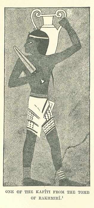
Drawn by Faucher-Gudin,
from the coloured sketches
by Prisse d'Avennes in
the Natural Hist. Museum.
All manufactures bore the impress of Babylonian influence, and their implements, weights, measures, and system of exchange were the same as those in use among the Chaldæans. The products of the country were, however, not sufficient to freight the fleets which sailed from Phoenicia every year bound for all parts of the known world, and additional supplies had to be regularly obtained from neighbouring peoples, who thus became used to pour into Tyre and Sidon the surplus of their manufactures, or of the natural wealth of their country. The Phoenicians were also accustomed to send caravans into regions which they could not reach in their caracks, and to establish trading stations at the fords of rivers, or in the passes over mountain ranges. We know of the existence of such emporia at Laish near the sources of the Jordan, at Thapsacus, and at Nisibis, and they must have served the purpose of a series of posts on the great highways of the world. The settlements of the Phoenicians always assumed the character of colonies, and however remote they might be from their fatherland, the colonists never lost the manners and customs of their native country. They collected together into their okels or storehouses such wares and commodities as they could purchase in their new localities, and, transmitting them periodically to the coast, shipped them thence to all parts of the world.
Not only were they acquainted with every part of the Mediterranean, but they had even made voyages beyond its limits. In the absence, however, of any specific records of their naval enterprise, the routes they followed must be a subject of conjecture. They were accustomed to relate that the gods, after having instructed them in the art of navigation, had shown them the way to the setting sun, and had led them by their example to make voyages even beyond the mouths of the ocean. El of Byblos was the first to leave Syria; he conquered Greece and Egypt, Sicily and Libya, civilizing their inhabitants, and laying the foundation of cities everywhere. The Sidonian Astartê, with her head surmounted by the horns of an ox, was the next to begin her wanderings over the inhabited earth. Melkarth completed the task of the gods by discovering and subjugating those countries which had escaped the notice of his predecessors. Hundreds of local traditions, to be found on all the shores of the Mediterranean down to Roman times, bore witness to the pervasive influence of the old Canaanite colonisation. At Cyprus, for instance, wo find traces of the cultus of Kinyras, King of Byblos and father of Adonis; again, at Crete, it is the daughter of a Prince of Sidon, Buropa, who is carried off by Zeus under the form of a bull; it was Kadmos, sent forth to seek Buropa, who visited Cyprus, Rhodes, and the Cyclades before building Thebes in Boeotia and dying in the forests of Illyria. In short, wherever the Phoenicians had obtained a footing, their audacious activity made such an indelible impression upon the mind of the native inhabitants that they never forgot those vigorous thick-set men with pale faces and dark beards, and soft and specious speech, who appeared at intervals in their large and swift sailing vessels. They made their way cautiously along the coast, usually keeping in sight of land, making sail when the wind was favourable, or taking to the oars for days together when occasion demanded it, anchoring at night under the shelter of some headland, or in bad weather hauling their vessels up the beach until the morrow. They did not shrink when it was necessary from trusting themselves to the open sea, directing their course by the Pole-star;* in this manner they often traversed long distances out of sight of land, and they succeeded in making in a short time voyages previously deemed long and costly.
     * The Greeks for this reason called it Phonikê, the
     Phoenician star; ancient writers refer to the use which the
     Phoenicians made of the Pole-star to guide them in
     navigation.
It is hard to say whether they were as much merchants as pirates—indeed, they hardly knew themselves—and their peaceful or warlike attitude towards vessels which they encountered on the seas, or towards the people whose countries they frequented, was probably determined by the circumstances of the moment.* If on arrival at a port they felt themselves no match for the natives, the instinct of the merchant prevailed, and that of the pirate was kept in the background. They landed peaceably, gained the good will of the native chief and his nobles by small presents, and spreading out their wares, contented themselves, if they could do no better, with the usual advantage obtained in an exchange of goods.
     * The manner in which the Phoenicians plied their trade is
     strikingly described in the Odyssey, in the part where
     Eumaios relates how he was carried off by a Sidonian vessel
     and sold as a slave: cf. the passage which mentions the
     ravages of the Greeks on the coast of the Delta. Herodotus
     recalls the rape of Io, daughter of Inachos, by the
     Phoenicians, who carried her and her companions into Egypt;
     on the other hand, during one of their Egyptian expeditions
     they had taken two priestesses from Thebes, and had
     transported one of them to Dodona, the other into Libya.
They were never in a hurry, and would remain in one spot until they had exhausted all the resources of the country, while they knew to a nicety how to display their goods attractively before the expected customer. Their wares comprised weapons and ornaments for men, axes, swords, incised or damascened daggers with hilts of gold or ivory, bracelets, necklaces, amulets of all kinds, enamelled vases, glass-work, stuffs dyed purple or embroidered with gay colours. At times the natives, whose cupidity was excited by the exhibition of such valuables, would attempt to gain possession of them either by craft or by violence. They would kill the men who had landed, or attempt to surprise the vessel during the night. But more often it was the Phoenicians who took advantage of the friendliness or the weakness of their hosts.
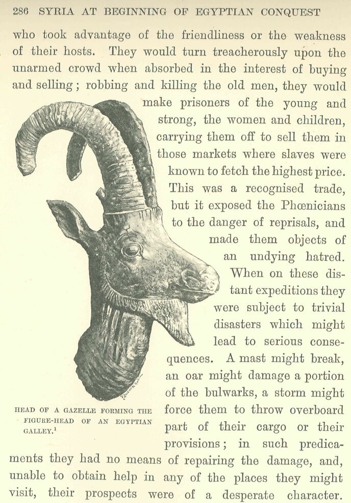
They would turn treacherously upon the unarmed crowd when absorbed in the interest of buying and selling; robbing and killing the old men, they would make prisoners of the young and strong, the women and children, carrying them off to sell them in those markets where slaves were known to fetch the highest price. This was a recognised trade, but it exposed the Phoenicians to the danger of reprisals, and made them objects of an undying hatred. When on these distant expeditions they were subject to trivial disasters which might lead to serious consequences. A mast might break, an oar might damage a portion of the bulwarks, a storm might force them to throw overboard part of their cargo or their provisions; in such predicaments they had no means of repairing the damage, and, unable to obtain help in any of the places they might visit, their prospects were of a desperate character. They soon, therefore, learned the necessity of establishing cities of refuge at various points in the countries with which they traded—stations where they could go to refit and revictual their vessels, to fill up the complement of their crews, to take in new freight, and, if necessary, pass the winter or wait for fair weather before continuing their voyage. For this purpose they chose by preference islands lying within easy distance of the mainland, like their native cities of Tyre and Arvad, but possessing a good harbour or roadstead. If an island were not available, they selected a peninsula with a narrow isthmus, or a rock standing at the extremity of a promontory, which a handful of men could defend against any attack, and which could be seen from a considerable distance by their pilots. Most of their stations thus happily situated became at length important towns. They were frequented by the natives from the interior, who allied themselves with the new-comers, and furnished them not only with objects of trade, but with soldiers, sailors, and recruits for their army; and such was the rapid spread of these colonies, that before long the Mediterranean was surrounded by an almost unbroken chain of Phoenician strongholds and trading stations.
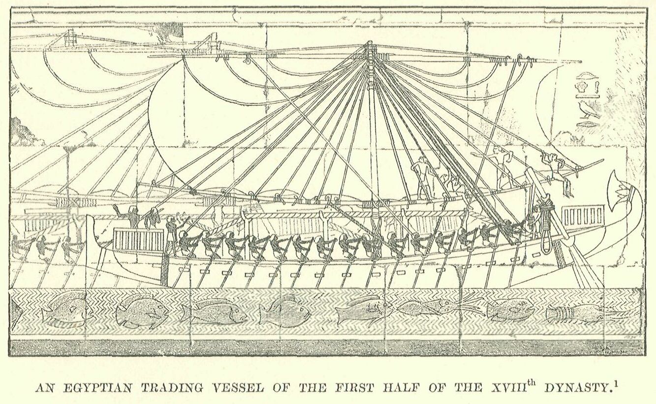
Drawn by Boudier, from a photograph by Beato.
All the towns of the mother country—Arvad, Byblos, Berytus, Tyre, and Sidon—possessed vessels engaged in cruising long before the Egyptian conquest of Syria. We have no direct information from any existing monument to show us what these vessels were like, but we are familiar with the construction of the galleys which formed the fleets of the Pharaohs of the XVIIIth dynasty. The art of shipbuilding had made considerable progress since the times of the Memphite kings. Prom the period when Egypt aspired to become one of the great powers of the world, she doubtless endeavoured to bring her naval force to the same pitch of perfection as her land forces could boast of, and her fleets probably consisted of the best vessels which the dockyards of that day could turn out. Phoenician vessels of this period may therefore be regarded with reason as constructed on lines similar to those of the Egyptian ships, differing from them merely in the minor details of the shape of the hull and manner of rigging. The hull continued to be built long and narrow, rising at the stem and stern. The bow was terminated by a sort of hook, to which, in time of peace, a bronze ornament was attached, fashioned to represent the head of a divinity, gazelle, or bull, while in time of war this was superseded by a metal cut-water made fast to the hull by several turns of stout rope, the blade rising some couple of yards above the level of the deck.* The poop was ornamented with a projection firmly attached to the body of the vessel, but curved inwards and terminated by an open lotus-flower. An upper deck, surrounded by a wooden rail, was placed at the bow and stern to serve as forecastle and quarterdecks respectively, and in order to protect the vessel from the danger of heavy seas the ship was strengthened by a structure to which we find nothing analogous in the shipbuilding of classical times: an enormous cable attached to the gammonings of the bow rose obliquely to a height of about a couple of yards above the deck, and, passing over four small crutched masts, was made fast again to the gammonings of the stern. The hull measured from the blade of the cut-water to the stern-post some twenty to five and twenty yards, but the lowest part of the hold did not exceed five feet in depth. There was no cabin, and the ballast, arms, provisions, and spare-rigging occupied the open hold.**
     * To get a clear idea of the details of this structure, we
     have only to compare the appearance of ships with and
     without a cut-water in the scenes at Thebes, representing
     the celebration of a festival at the return of the fleet.

     ** M. Glaser thinks that there were cabins for the crew
     under the deck, and he recognises in the sixteen oblong
     marks on the sides of the vessels at Deîr el-Bahari so many
     dead-lights; as there could not have been space for so many
     cabins, I had concluded that these were ports for oars to be
     used in time of battle, but on further consideration I saw
     that they represented the ends of the beams supporting the
     deck.
The bulwarks were raised to a height of some two feet, and the thwarts of the rowers ran up to them on both the port and starboard sides, leaving an open space in the centre for the long-boat, bales of merchandise, soldiers, slaves, and additional passengers.* A double set of steering-oars and a single mast completed the equipment. The latter, which rose to a height of some twenty-six feet, was placed amidships, and was held in an upright position by stays. The masthead was surmounted by two arrangements which answered respectively to the top ["gabie"] and calcet of the masts of a galley.** There were no shrouds on each side from the masthead to the rail, but, in place of them, two stays ran respectively to the bow and stern. The single square-sail was extended between two yards some sixty to seventy feet long, and each made of two pieces spliced together at the centre. The upper yard was straight, while the lower curved upward at the ends. The yard was hoisted and lowered by two halyards, which were made fast aft at the feet of the steersmen. The yard was kept in its place by two lifts which came down from the masthead, and were attached respectively about eight feet from the end of each yard-arm. When the yard was hauled up it was further supported by six auxiliary lifts, three being attached to each yard-arm. The lower yard, made fast to the mast by a figure-of-eight knot, was secured by sixteen lifts, which, like those of the upper yard, worked through the "calcet."
     * One of the bas-reliefs exhibits a long-boat in the water
     at the time the fleet was at anchor at Puanît. As we do not
     find any vessel towing one after her, we naturally conclude
     that the boat must have been stowed on board.

     ** The "gabie" was a species of top where a sailor was placed
     on the look-out. The "calcet" is, properly speaking, a
     square block of wood containing the sheaves on which the
     halyards travelled. The Egyptian apparatus had no sheaves,
     and answers to the "calcet" on the masts of a galley only in
     its serving the same purpose.
The crew comprised thirty rowers, fifteen on each side, four top-men, two steersmen, a pilot at the bow, who signalled to the men at the helm the course to steer, a captain and a governor of the slaves, who formed, together with ten soldiers, a total of some fifty men.* In time of battle, as the rowers would be exposed to the missiles of the enemy, the bulwarks were further heightened by a mantlet, behind which the oars could be freely moved, while the bodies of the men were fully protected, their heads alone being visible above it. The soldiers were stationed as follows: two of them took their places on the forecastle, a third was perched on the masthead in a sort of cage improvised on the bars forming the top, while the remainder were posted on the deck and poop, from which positions and while waiting for the order to board they could pour a continuous volley of arrows on the archers and sailors of the enemy.**
     * I have made this calculation from an examination of the
     scenes in which ships are alternatively represented as at
     anchor and under weigh. I know of vessels of smaller size,
     and consequently with a smaller crew, but I know of none
     larger or more fully manned.

     ** The details are taken from the only representation of a
     naval battle which we possess up to this moment, viz. that
     of which I shall have occasion to speak further on in
     connection with the reign of Ramses III.
The first colony of which the Phoenicians made themselves masters was that island of Cyprus whose low, lurid outline they could see on fine summer evenings in the glow of the western sky. Some hundred and ten miles in length and thirty-six in breadth, it is driven like a wedge into the angle which Asia Minor makes with the Syrian coast: it throws out to the north-east a narrow strip of land, somewhat like an extended finger pointing to where the two coasts meet at the extremity of the gulf of Issos. A limestone cliff, of almost uniform height throughout, bounds, for half its length at least, the northern side of the island, broken occasionally by short deep valleys, which open out into creeks deeply embayed. A scattered population of fishermen exercised their calling in this region, and small towns, of which we possess only the Greek or Grecised names—Karpasia, Aphrodision, Kerynia, Lapethos—led there a slumbering existence. Almost in the centre of the island two volcanic peaks, Troodes and Olympos, face each other, and rise to a height of nearly 7000 feet, the range of mountains to which they belong—that of Aous—forming the framework of the island. The spurs of this range fall by a gentle gradient towards the south, and spread out either into stony slopes favourable to the culture of the vine, or into great maritime flats fringed with brackish lagoons. The valley which lies on the northern side of this chain runs from sea to sea in an almost unbroken level. A scarcely perceptible watershed divides the valley into two basins similar to those of Syria, the larger of the two lying opposite to the Phoenician coast. The soil consists of black mould, as rich as that of Egypt, and renewed yearly by the overflowing of the Pediæos and its affluents. Thick forests occupied the interior, promising inexhaustible resources to any naval power. Even under the Koman emperors the Cypriotes boasted that they could build and fit out a ship from the keel to the masthead without looking to resources beyond those of their own island. The ash, pine, cypress, and oak flourished on the sides of the range of Aous, while cedars grew there to a greater height and girth than even on the Lebanon. Wheat, barley, olive trees, vines, sweet-smelling woods for burning on the altar, medicinal plants such as the poppy and the ladanum, henna for staining with a deep orange colour the lips, eyelids, palm, nails, and fingertips of the women, all found here a congenial habitat; while a profusion everywhere of sweet-smelling flowers, which saturated the air with their penetrating odours—spring violets, many-coloured anemones, the lily, hyacinth, crocus, narcissus, and wild rose—led the Greeks to bestow upon the island the designation of "the balmy Cyprus." Mines also contributed their share to the riches of which the island could boast. Iron in small quantities, alum, asbestos, agate and other precious stones, are still to be found there, and in ancient times the neighbourhood of Tamassos yielded copper in such quantities that the Romans were accustomed to designate this metal by the name "Cyprium," and the word passed from them into all the languages of Europe. It is not easy to determine the race to which the first inhabitants of the island belonged, if we are not to see in them a branch of the Kefâtiu, who frequented the Asiatic shores of the Mediterranean from a very remote period. In the time of Egyptian supremacy they called their country Asi, and this name inclines one to connect the people with the Ægeans.* An examination of the objects found in the most ancient tombs of the island seems to confirm this opinion. These consist, for the most part, of weapons and implements of stone—knives, hatchets, hammers, and arrow-heads; and mingled with these rude objects a score of different kinds of pottery, chiefly hand-made and of coarse design—pitchers with contorted bowls, shallow buckets, especially of the milk-pail variety, provided with spouts and with pairs of rudimentary handles.
     * "Asi," "Asîi," was at first sought for on the Asiatic
     continent—at Is on the Euphrates, or in Palestine: the
     discovery of the Canopic decree allows us to identify it
     with Cyprus, and this has now been generally done. The
     reading "Asebi" is still maintained by some.
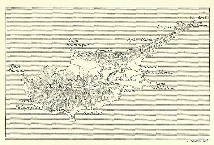
The pottery is red or black in colour, and the ornamentation of it consists of incised geometrical designs. Copper and bronze, where we find examples of these metals, do not appear to have been employed in the manufacture of ornaments or arrow-heads, but usually in making daggers. There is no indication anywhere of foreign influence, and yet Cyprus had already at this time entered into relations with the civilized nations of the continent.* According to Chaldæan tradition, it was conquered about the year 3800 B.C. by Sargon of Agadê: without insisting upon the reality of this conquest, which in any case must have been ephemeral in its nature, there is reason to believe that the island was subjected from an early period to the influence of the various peoples which lived one after another on the slopes of the Lebanon. Popular legend attributes to King Kinyras and to the Giblites [i.e. the people of Byblos] the establishment of the first Phoenician colonies in the southern region of the island—one of them being at Paphos, where the worship of Adonis and Astartê continued to a very late date. The natives preserved their own language and customs, had their own chiefs, and maintained their national independence, while constrained to submit at the same time to the presence of Phoenician colonists or merchants on the coast, and in the neighbourhood of the mines in the mountains. The trading centres of these settlers—Kition, Amathus, Solius, Golgos, and Tamassos—were soon, however, converted into strongholds, which ensured to Phonicia the monopoly of the immense wealth contained in the island.**
     * An examination into the origin of the Cypriotes formed
     part of the original scheme of this work, together with that
     of the monuments of the various races scattered along the
     coast of Asia Minor and the islands of the Ægean; but I
     have been obliged to curtail it, in order to keep within the
     limits I had proscribed for myself, and I have merely
     epitomised, as briefly as possible, the results of the
     researches undertaken in those regions during the last few
     years.

     ** The Phoenician origin of these towns is proved by
     passages from classical writers. The date of the
     colonisation is uncertain, but with the knowledge we possess
     of the efficient vessels belonging to the various Phoenician
     towns, it would seem difficult not to allow that the coasts
     at least of Cyprus must have been partially occupied at the
     time of the Egyptian invasions.
Tyre and Sidon had no important centres of industry on that part of the Canaanite coast which extended to the south of Carmel, and Egypt, even in the time of the shepherd kings, would not have tolerated the existence on her territory of any great emporium not subject to the immediate supervision of her official agents. We know that the Libyan cliffs long presented an obstacle to inroads into Egyptian territory, and baffled any attempts to land to the westwards of the Delta: the Phoenicians consequently turned with all the greater ardour to those northern regions which for centuries had furnished them with most valuable products—bronze, tin, amber, and iron, both native and wrought. A little to the north of the Orontes, where the Syrian border is crossed and Asia Minor begins, the coast turns due west and runs in that direction for a considerable distance. The Phoenicians were accustomed to trade along this region, and we may attribute, perhaps, to them the foundation of those obscure cities—Kibyra, Masura, Euskopus, Sylion, Mygdalê, and Sidyma*—all of which preserved their apparently Semitic names down to the time of the Roman epoch. The whole of the important island of Rhodes fell into their power, and its three ports, Ialysos, Lindos*, and Kamiros, afforded them a well-situated base of operations for further colonisation. On leaving Rhodes, the choice of two routes presented itself to them. To the south-west they could see the distant outline of Karpathos, and on the far horizon behind it the summits of the Cretan chain. Crete itself bars on the south the entrance to the Ægean, and is almost a little continent, self-contained and self-sufficing.
     * No direct evidence exists to lead us to attribute the
     foundation of these towns to the Phoenicians, but the
     Semitic origin of nearly all the names is an uncontested
     fact.
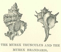
It is made up of fertile valleys and mountains clothed with forests, and its inhabitants could employ themselves in mines and fisheries. The Phoenicians effected a settlement on the coast at Itanos, at Kairatos, and at Arados, and obtained possession of the peak of Cythera, where, it is said, they raised a sanctuary to Astartê. If, on leaving Rhodes, they had chosen to steer due north, they would soon have come into contact with numerous rocky islets scattered in the sea between the continents of Asia and Europe, which would have furnished them with as many stations, less easy of attack, and more readily defended than posts on the mainland. Of these the Giblites occupied Melos, while the Sidonians chose Oliaros and Thera, and we find traces of them in every island where any natural product, such as metals, sulphur, alum, fuller's earth, emery, medicinal plants, and shells for producing dyes, offered an attraction. The purple used by the Tyrians for dyeing is secreted by several varieties of molluscs common in the Eastern Mediterranean; those most esteemed by the dyers were the Murex trunculus and the Murex Brandaris, and solid masses made up of the detritus of these shells are found in enormous quantities in the neighbourhood of many Phoenician towns. The colouring matter was secreted in the head of the shellfish. To obtain it the shell was broken by a blow from a hammer, and the small quantity of slightly yellowish liquid which issued from the fracture was carefully collected and stirred about in salt water for three days.
It was then boiled in leaden vessels and reduced by simmering over a slow fire; the remainder was strained through a cloth to free it from the particles of flesh still floating in it, and the material to be dyed was then plunged into the liquid. The usual tint thus imparted was that of fresh blood, in some lights almost approaching to black; but careful manipulation could produce shades of red, dark violet, and amethyst. Phoenician settlements can be traced, therefore, by the heaps of shells upon the shore, the Cyclades and the coasts of Greece being strewn with this refuse. The veins of gold in the Pangaion range in Macedonia attracted them off the Thracian coast* received also frequent visits from them, and they carried their explorations even through the tortuous channel of the Hellespont into the Propontis, drawn thither, no doubt by the silver mines in the Bithynian mountains** which were already being worked by Asiatic miners.
     * The fact that they worked the mines of Thasos is attested
     by Herodotus.

     ** Pronektos, on the Gulf of Ascania, was supposed to be a
     Phoenician colony.
Beyond the calm waters of the Propontis, they encountered an obstacle to their progress in another narrow channel, having more the character of a wide river than of a strait; it was with difficulty that they could make their way against the violence of its current, which either tended to drive their vessels on shore, or to dash them against the reefs which hampered the navigation of the channel. When, however, they succeeded in making the passage safely, they found themselves upon a vast and stormy sea, whose wooded shores extended east and west as far as eye could reach.
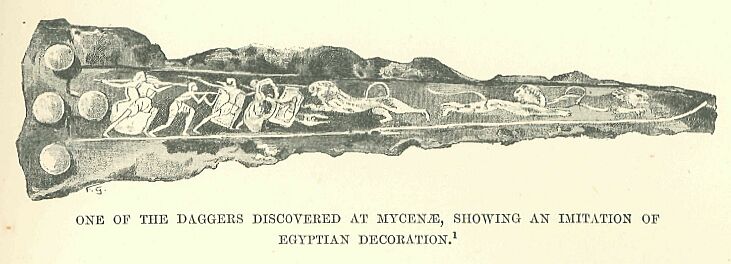
Drawn by Faucher-Gudin, from the facsimile in Perrot-Chipiez.
From the tribes who inhabited them, and who acted as intermediaries, the Phoenician traders were able to procure tin, lead, amber, Caucasian gold, bronze, and iron, all products of the extreme north—a region which always seemed,to elude their persevering efforts to discover it. We cannot determine the furthest limits reached by the Phoenician traders, since they were wont to designate the distant countries and nations with which they traded by the vague appellations of "Isles of the Sea" and "Peoples of the Sea," refusing to give more accurate information either from jealousy or from a desire to hide from other nations the sources of their wealth.
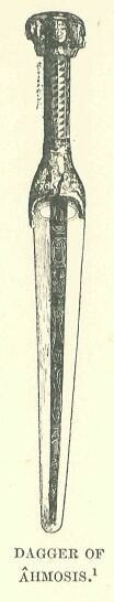
Drawn by
Faucher-
Gudin.
The peoples with whom they traded were not mere barbarians, contented with worthless objects of barter; their clients included the inhabitants of the iEgean, who, if inferior to the great nations of the East, possessed an independent and growing civilization, traces of which are still coming to light from many quarters in the shape of tombs, houses, palaces, utensils, ornaments, representations of the gods, and household and funerary furniture,—not only in the Cyclades, but on the mainland of Asia Minor and of Greece. No inferior goods or tinsel wares would have satisfied the luxurious princes who reigned in such ancient cities as Troy and Mycenae, and who wanted the best industrial products of Egypt and Syria—costly stuffs, rare furniture, ornate and well-wrought weapons, articles of jewellery, vases of curious and delicate design—such objects, in fact, as would have been found in use among the sovereigns and nobles of Memphis or of Babylon. For articles to offer in exchange they were not limited to the natural or roughly worked products of their own country. Their craftsmen, though less successful in general technique than their Oriental contemporaries, exhibited considerable artistic intelligence and an extraordinary manual skill. Accustomed at first merely to copy the objects sold to them by the Phoenicians, they soon developed a style of their own; the Mycenaean dagger in the illustration on page 299, though several centuries later in date than that of the Pharaoh Ahmosis, appears to be traceable to this ancient source of inspiration, although it gives evidence of new elements in its method of decoration and in its greater freedom of treatment. The inhabitants of the valleys of the Nile and of the Orontes, and probably also those of the Euphrates and Tigris, agreed in the, high value they set upon these artistic objects in gold, silver, and bronze, brought to them from the further shores of the Mediterranean, which, while reproducing their own designs, modified them to a certain extent; for just as we now imitate types of ornamental work in vogue among nations less civilized than ourselves, so the iEgean people set themselves the task through their potters and engravers of reproducing exotic models. The Phoenician traders who exported to Greece large consignments of objects made under various influences in their own workshops, or purchased in the bazaars of the ancient world, brought back as a return cargo an equivalent number of works of art, bought in the towns of the West, which eventually found their way into the various markets of Asia and Africa. These energetic merchants were not the first to ply this profitable trade of maritime carriers, for from the time of the Memphite empire the products of northern regions had found their way, through the intermediation of the Haûinibû, as far south as the cities of the Delta and the Thebaid. But this commerce could not be said to be either regular or continuous; the transmission was carried on from one neighbouring tribe to another, and the Syrian sailors were merely the last in a long chain of intermediaries—a tribal war, a migration, the caprice of some chief, being sufficient to break the communication, and even cause the suspension of transit for a considerable period. The Phoenicians desired to provide against such risks by undertaking themselves to fetch the much-coveted objects from their respective sources, or, where this was not possible, from the ports nearest the place of their manufacture. Reappearing with each returning year in the localities where they had established emporia, they accustomed the natives to collect against their arrival such products as they could profitably use in bartering with one or other of their many customers. They thus established, on a fixed line of route, a kind of maritime trading service, which placed all the shores of the Mediterranean in direct communication with each other, and promoted the blending of the youthful West with the ancient East.
| Previous Part | Main Index | Next Part |